|
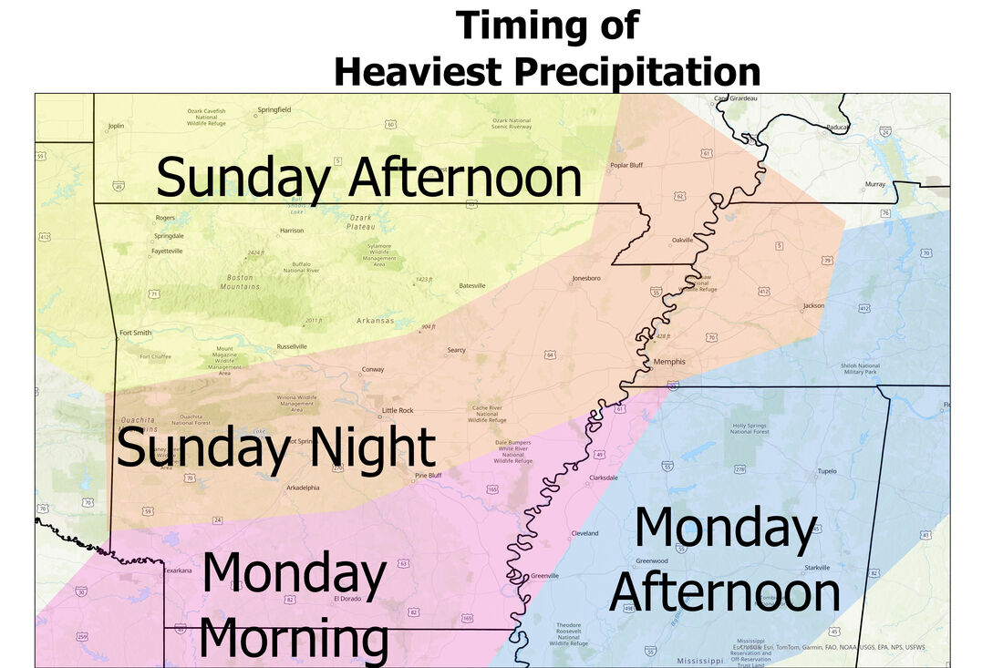
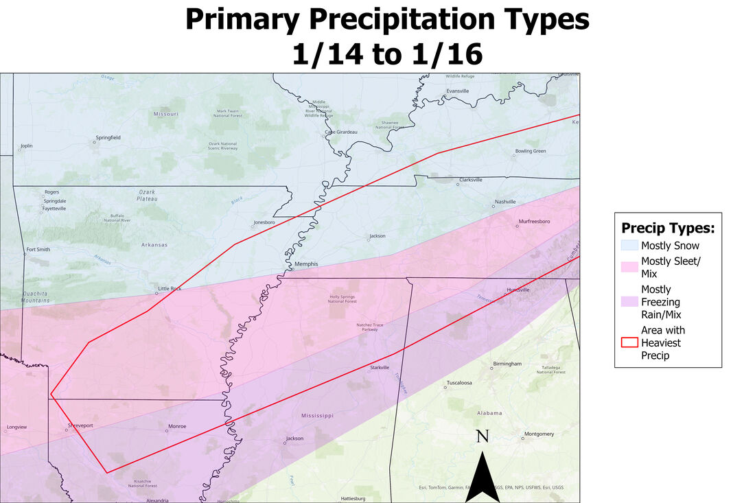
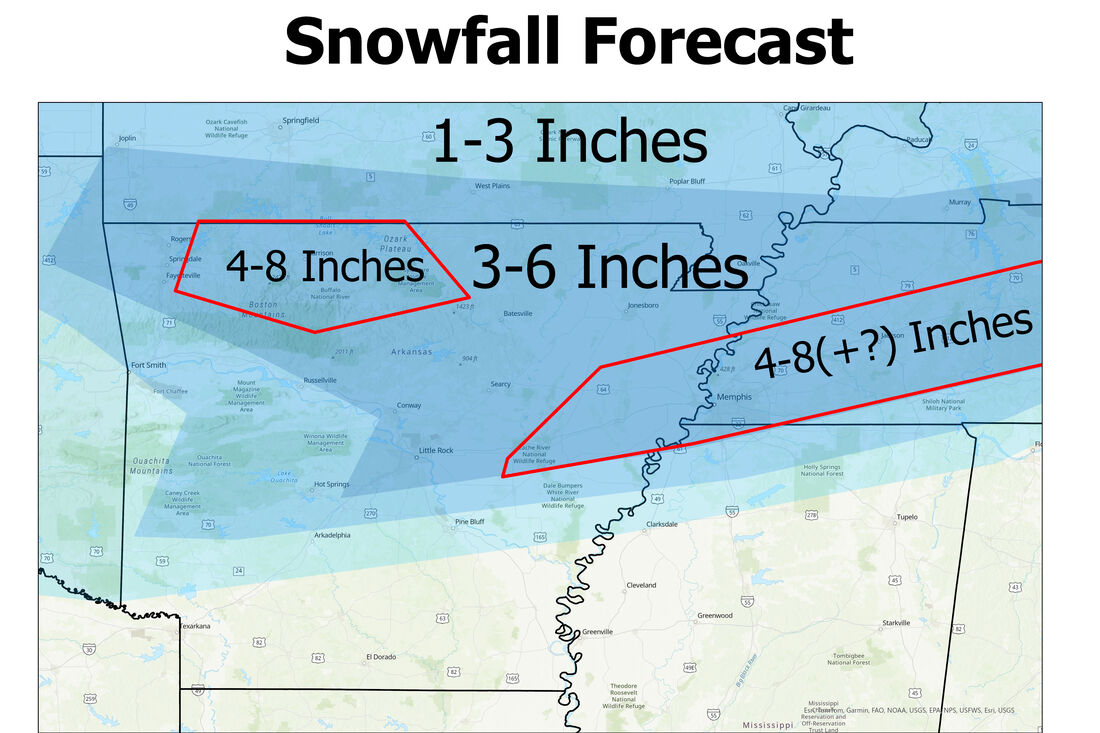
Good morning everyone! Happy Saturday! It is COLD here in Jonesboro, but it is winter of course! Only a couple of months until actual warm weather! I'll be counting down to March after next week's weather! See below for a full discussion of the upcoming event, scroll down to see my snowfall forest as of 11am on Saturday. General Notes about the Setup of the Event: As some of you may know, we have a chance for snow (or at least here in northeast Arkansas) Sunday and Monday. This is an interesting setup. There is no actual system that this is tied to, or at least for here. A large band of snow will move out of the Rockies associated with a system in the west, but the short dip in the jet stream that caused the system falls apart, therefore leaving a band of snow that moves into the southern Midwest Sunday afternoon and into the night. This will be the heaviest snow for southern Missouri & northern Arkansas. Then a stronger dip in the jet stream develops Monday, in which a system starts to develop in the southeast. This causes a 'revamp' in wintery precipitation across the Lower Mississippi River Valley across LA, AR, MS, and western TN Monday morning and afternoon. More specially a band of stronger precipitation from S/C AR, W TN, and the northern half of MS that will move east throughout Monday afternoon. See below for the timing of the heaviest precipitation times for the event: Precipitation Types: This is a hard to forecast for types of precipitation, especially for areas south of Interstate 40. The event will begin as all snow north of I40 Sunday afternoon and evening, but once the precipitation reaches the I40 corridor, most locations south have a large enough temperature inversion in the lower levels of the atmosphere to cause sleet to fall, and later even farther south freezing rain. The models vary between mostly sleet (HRRR) or mostly freezing rain (NAM) for the areas labeled as 'mix' in the below figure, but overall just know in the areas either labeled as Freezing Rain or Sleet, there will be a mix for most of the event (less than .25 of an inch for most of the region, especially in the western half). This is just my thought for now: Snow Accumulation Forecast: Now for locations along and north of Interstate 40, there will be plenty of snow to come, although the models have varied all week with the totals. Even as of yesterday, some long-range models were throwing out 12-18 totals or 1-2 totals for northeast Arkansas. So far the short-range models have agreed with most locations receiving accumulations more in the middle, but I'll have a more detailed forecast with more specific amounts tomorrow morning (Sunday) as models become more accurate with the placement of the heaviest snow as well as how much. Overall, the heaviest snow will likely fall just north of this snow/sleet transition line along and north of Interstate 40 from Sunday night to early Monday afternoon, with break periods or lighter snow Monday morning as the precipitation ramps back up in the afternoon from Little Rock and east. See the map as for broad range amounts, but I have a few locations below for more specific information on how much to expect and when: ALL FORECASTS ARE SUBJECT TO CHANGE Jonesboro 2-5 inches Sunday Afternoon: None (flurries starting around sunset) Sunday Night: 1-3 inches Monday: Around 1 inch Heaviest Snow: 6pm-12am Sunday night Memphis: 5-8 inches Sunday Afternoon: None Sunday Night: 3-6 inches Monday: 1-3 inches Heaviest snow: 9pm-3am Sunday Night & 9am-3pm Monday (some may fall as sleet) Little Rock 2-5 inches Sunday Afternoon: None Sunday Night: 1-3 inches Monday: 1-2 inches Heaviest Snow: 9pm-3am Sunday Night Bentonville/Fayetteville: 3-6 inches Sunday Afternoon: 3-6 Inches Sunday Night/Monday: None Heaviest Snow: 12pm-6pm Sunday Thanks for reading and another update will be posted tomorrow morning around the same time (10/11am). This may all change, as weather models always throw something different right before any event, but nonetheless expect some snow and wintry precipitation throughout the Lower Mississippi River Valley! Also note extreme cold which arrives Sunday into Monday and lasts until Thursday throughout the region!
0 Comments
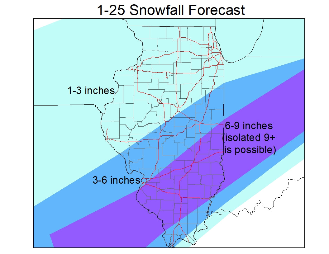
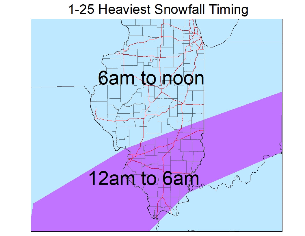
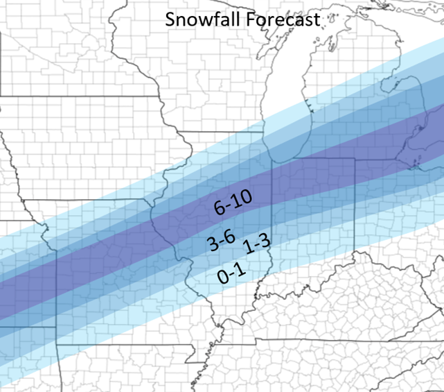
Good afternoon! I hope everyone has had a great start to the year! Unlike usual, I will start out with my official (current) forecast of this upcoming event and what to (generally) expect throughout, then a short explanation of the event. There will be a fairly sharp gradient in S IL between 6+ totals and close to nothing. A shift in 25 miles can mean the difference of very different totals downstate. Specific forecasts for a few locations are below the forecast as well: Central IL: Jacksonville: 2-4 Peoria: 1-3 Bloomington: 2-4 Springfield: 2-4 Decatur: 3-5 Champaign: 4-6 Danville: 5-8 Kankakee: 2-4 Southern IL: Effingham: 6-9 Olney: 6-9 Carlyle: 6-9 East St. Louis: 3-5 Carbondale: 5-8 Northern IL: 1-2 throughout with some isolated 2-3 inch totals General synopsis:
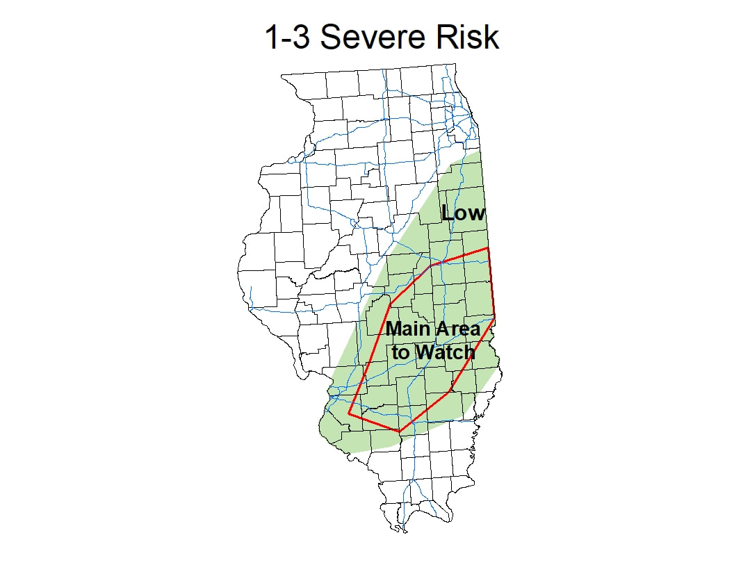
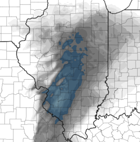
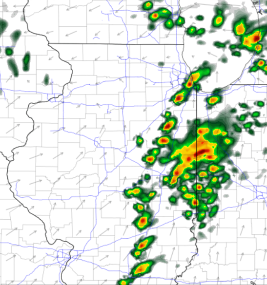
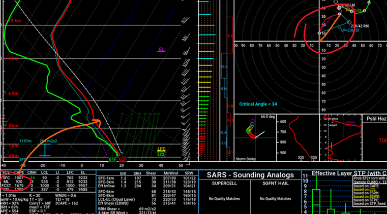
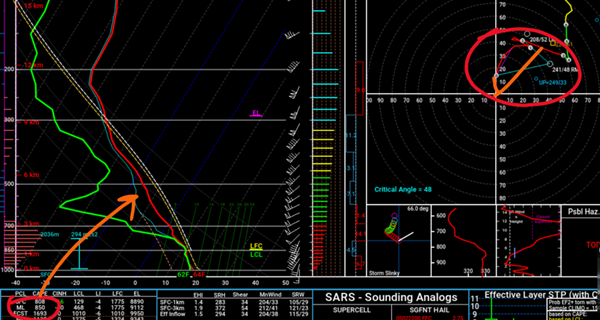
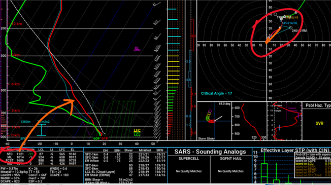
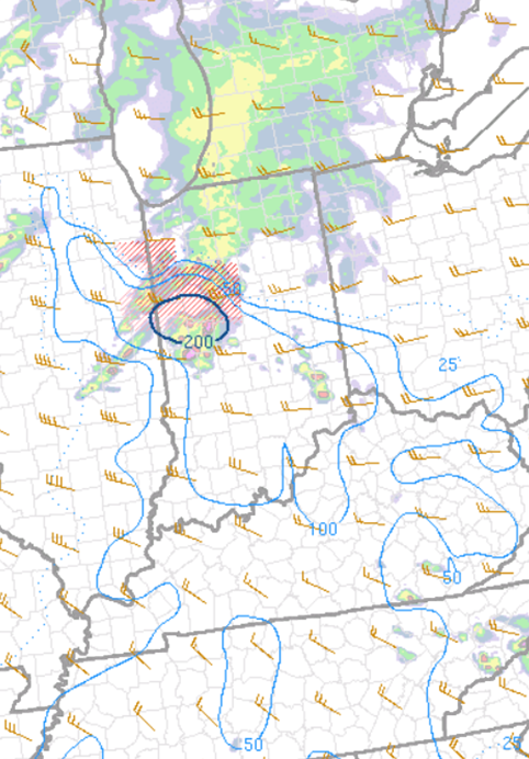
This event will start as primarily rain before midnight in most areas south of I72. Temperatures start out in the mid 30s and very slowly fall into low 30s by midnight. Rain will start to transition to snow between 10pm and midnight in southern IL and will continue to transition into snow to the north around and after midnight. The heaviest snow as displayed above will occur roughly south of I70 before 6am with this initial patch of precip. Areas from Cape Girardeau to Harrisburg and south will be on the gradient line between mostly rain and mostly snow. A slight shift in the track can mean the difference between 1 inch and 7 inches for most locations within 25 miles of this line. Mixing will occur again as the low pressure nears during the late night hours as well. The heaviest snow in Central IL will fall 6-10am, especially in East-central IL. Generally, the bands of heaviest snow will fall in and around the I70 corridor (mostly just south). Snow will generally taper off from SW to NE during the late morning and early afternoon on Wednesday. Thankfully, winds will not be too gusty unlike many major snowstorms that come through our region. Winds will roughly be 15-20mph throughout the event. Another inch or so will be likely between Wednesday night and Thursday throughout most of IL and that inch is not included in the forecast above! Good morning everyone! Who's ready for record warmth today in Eastern Illinois?! This warmth (highs in mid 60s) will also fuel an environment potentially favorable for severe weather this afternoon in portions of Southern and Eastern Illinois. All risks are possible including a tornado or two. This environment is marginally ample, meaning conditions are ample enough to produce a few supercells, but not ample enough for any significant event or development of storms. The main timing is from 1 to 6 pm, more particuarly 2 to 5 pm. Any storms will fire from near and just east of the STL metro area and will quickly move northeast. Below is a map of the target areas and after the map I explain the set up for today! Environment for today: As stated before, this is a marginally ample environment. This is similar to a couple very active December events in Illinois over the past decade. A powerful system sits over or near Iowa, storms persist over the south, but a small area of favorable conditions forms near the low pressure over Illinois. Although instability is looking slightly more supportive over the last few hours, wind shear is not near strong enough to support a substantial tornado event like these prior events. There is still modest wind shear available today, with SRH values 150-200 across the region, more specifically along and near I70, but are modest wind shears with CAPE values 750-1250 (possibly breaking 1250). In order to see a small outbreak, SRH (wind shear) values would have to be closer to 300 with the lower CAPE values. Still, between the marginal instability and modest wind shear, severe weather is still possible across the region, mostly along the nose of the small warm section in front of the cold front. Below I have a few screenshots showing the instability and a few weather soundings with descriptions of what to look for in the captions! Thanks for reading and if anything significant changes I'll post again! HRRR ML CAPE values at 2pm, the blue colors are CAPE values of greater than 1,000 and are ample enough to energize storms that develop. This corridor will move east throughout the afternoon. Generally for severe storm development, CAPE values of greater than 1,000 are needed. HRRR at 5pm (7am model) HRRR forecast weather sounding from Douglas County at 5pm. I circled the CAPE value (arrow pointing to how this value is calculated, the area between the temp and the dotted line (parcel temp) and the hodograph (wind shear). When looking at a hodograph, on favorable days, (simple explanation) the more hooked or curved the line on the graph is the more wind shear/ample for tornadoes. This hodograph is good (look at the third hodo for a much less favorable one) because surface winds are 10-15kts from the S and slightly higher up are 40kts from the SW, showing a curved appearance. This shows both speed and directional shear. Although stronger SW winds higher up and a more SE flow near the surface would be more favorable. NAM over Randolph County at 2pm, showing slightly less favorable CAPE but a much more favorable hodograph. Even more curved than the one before, a hodograph like this is supportive for supercell development and tornadoes. 15kt S surface wind and 50kt SW wind towards the mid levels. HRRR 4pm weather sounding from Ford County. Supportive CAPE values but the hodograph is much less favorable, nearly linear with SW or near SW winds at the surface and at mid levels. Need supportive CAPE values to co-locate with ample wind shear for the best potential!
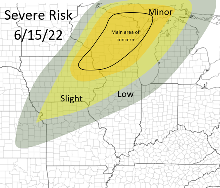
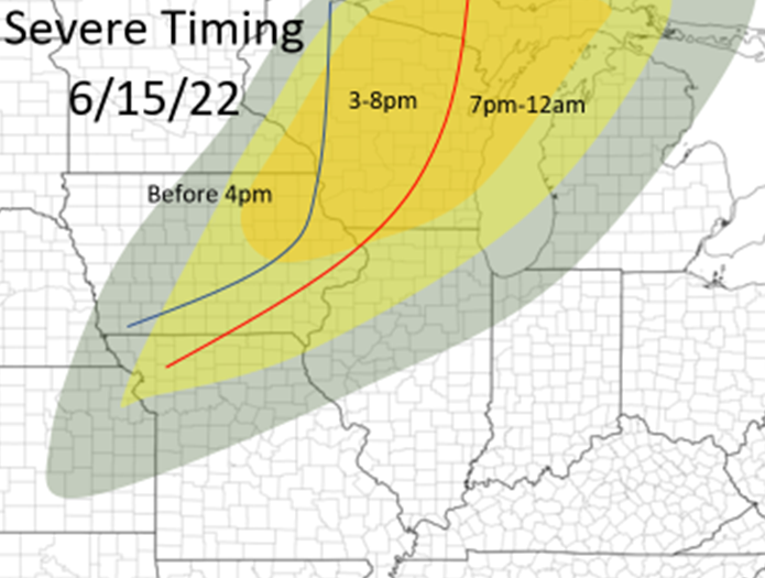
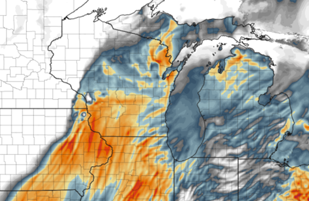
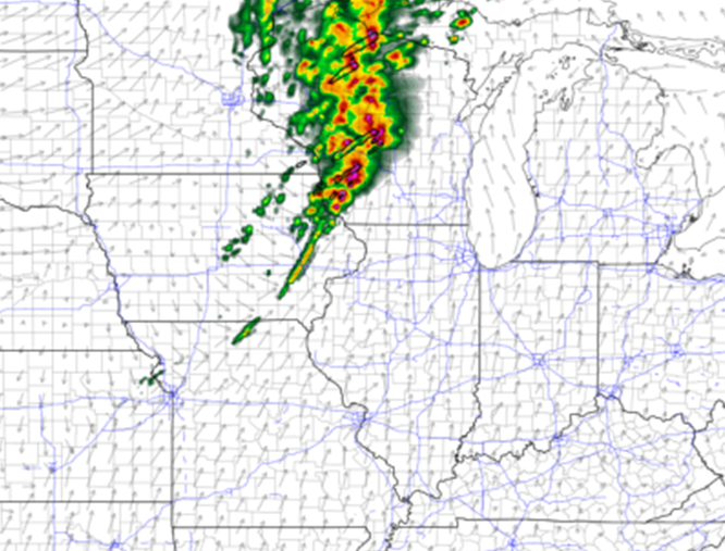
Good morning everyone! Today's risk the main focus will be across a large portion of Wisconsin, as well as Northeastern Iowa and Western Upper Peninsula of Michigan. All threats will be likely including a few tornadoes, some could be quite strong. The main timing of this event will be 2-8pm, although more of a damaging wind threat after 8 across portions of Eastern Wisconsin, Northern Illinois, and other parts of the Upper Peninsula of Michigan. Below I have my outlook and timing for the event today: The storms will fire between 1-4pm over portions of Northeastern Iowa, far Southeastern Minnesota, and Western Wisconsin, and track northeast. The main tornado risk is earlier this evening, across portions of Iowa, Western and Northern half of Wisconsin (areas within the minor risk), and the Western Upper Peninsula of Michigan. CAPE values will be 2500+ across most of this area, the best shear will be across areas in Northern Wisconsin with a more southerly to southeasterly surface flow, although in areas with greater CAPE across all areas of southern Wisconsin (seen in picture below). There is also a slight concern about this morning convection coming out of Iowa by inhibit the extent or intensity of CAPE to Northern Wisconsin this afternoon. Early on in the afternoon should have enough shear to also pose a strong tornado threat as well in Southern Wisconsin, before winds become more southwesterly producing less ample wind shear for tornadic storms. After these storms move into Eastern Wisconsin this afternoon and nearby areas, the storms will become more linear in mode and pose a more damaging wind threat, although all threats can not be ruled out. All for now! Stay tuned for more! HRRR CAPE map from the afternoon, showing higher CAPE values in Southern Wisconsin but stronger wind shear will likely be across areas of Northern Wisconsin, but strong shear will be all throughout the threat area today HRRR at 5pm, showing a line of storms erupting across Western and Central Wisconsin
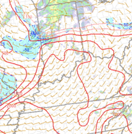
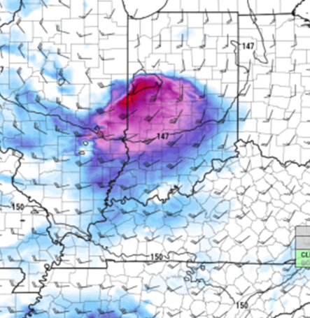
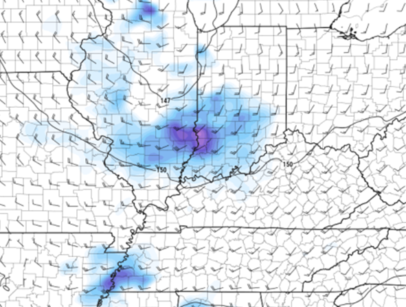
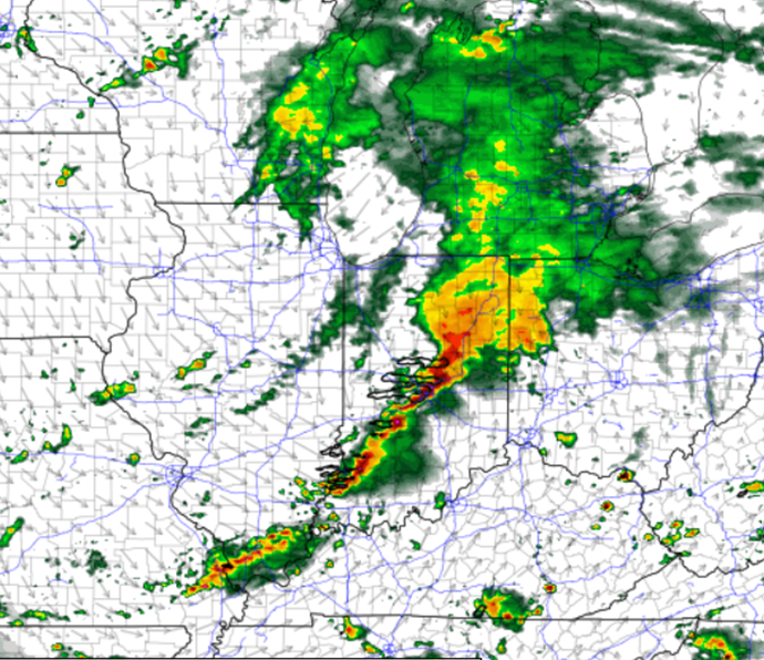
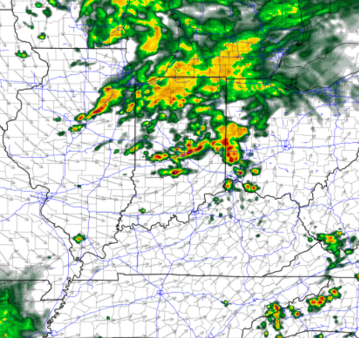
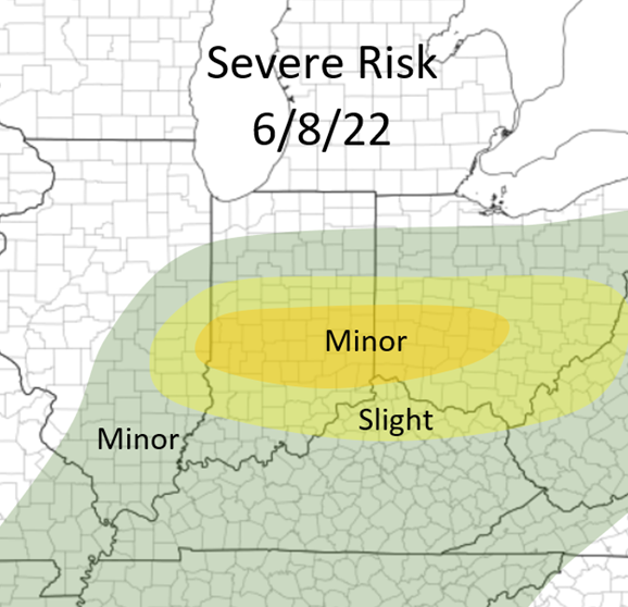
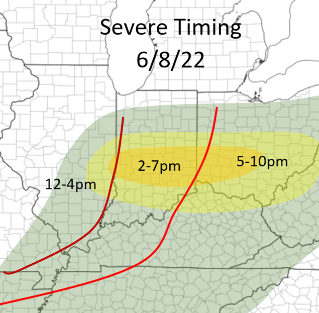
Good morning everyone! I haven't talked about weather in a long time! This has been a more quiet spring for our region so far, although that is likely to change in the coming weeks! Today's threat will focus in the Eastern Midwest and into the Eastern Ohio River Valley throughout this afternoon. All threats will be likely with a few tornados possible, especially across Indiana and Western Ohio, but even at this time there are still some uncertainties. Nonetheless, all threats will be likely from Western Ohio and west, and areas to the east of Western Ohio it will be a more damaging wind threat. As of now, it appears storms will develop near the Illinois/Indiana border and areas nearby to the east. The HRRR is hinting at more development across the I74 corridor early on and a more messy set up along the advancing warm front. The NAM shows a more clean warm sector with storms forming along the Stateline and moving east. The important factors are the amount of wind shear and the amount of CAPE (instability) that will be in place ahead of this set up. Before I talk about the main models, I'll bring up 14z mesoscale analysis and the 6 hour forecast from this on the SPC website. This to me is showing a mix between the two models, suggesting CAPE values of 1000-1500+ will be in place near the target area by 4pm ET with ample wind shear getting in place by this time as well. Mesoscale Analysis of Storm Relative Helicity at 4pm ET Mesoscale Analysis of CAPE at 4pm ET The main problem with the HRRR is showing the lack of low level winds, especially at around 850mb in the atmosphere. The NAM shows a very robust and strong 850mb jet over the target area, and slightly more southerly. The HRRR doesn't necessarily show a tightening low over Central Indiana by 5pm ET which makes the winds more out of the southwest, closer to the lower levels as well, along with the lack of stronger winds. Also, the HRRR shows slightly less instability than the NAM, correlating with a more messy set up and not as a clear atmosphere from this morning's convection. NAM 850mb winds at 3pm ET HRRR 850mb winds at 3pm ET NAM at 5pm ET HRRR 5pm ET Nonetheless, severe weather will be likely across this area throughout this afternoon. Below I have an outlook I made for today along with general timings for the severe weather. I am a little bold with the outlook with including a "minor" risk although between the NAM and the mesoscale analysis I'm feeling more confident with this area being the focus area for severe weather today. I could be wrong, but we will see how today goes and I'll learn, weather is always changing!
All for today! I am leaving to go chase for the first time in nearly a month! Stay tuned! Good morning everyone, here's to the first very active day of 2022 throughout our region!
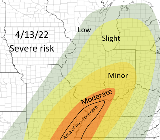
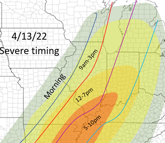
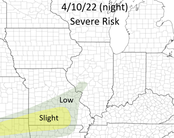
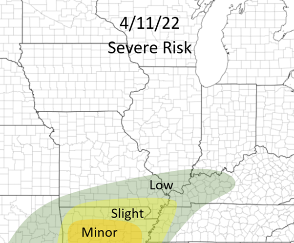
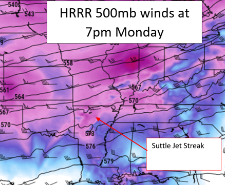
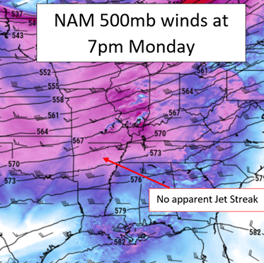
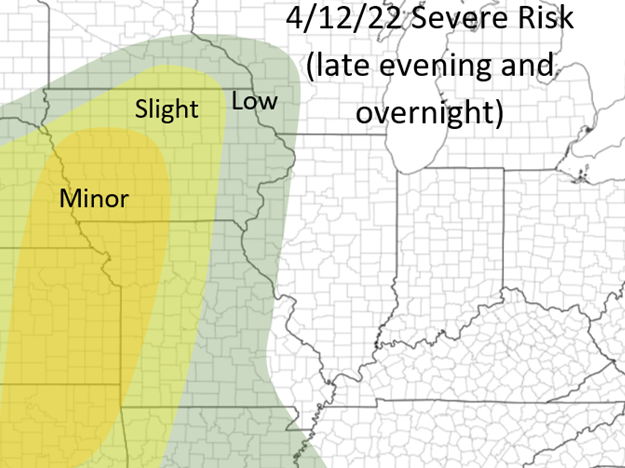
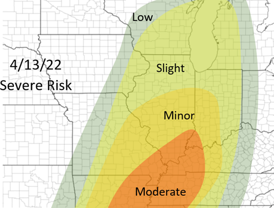
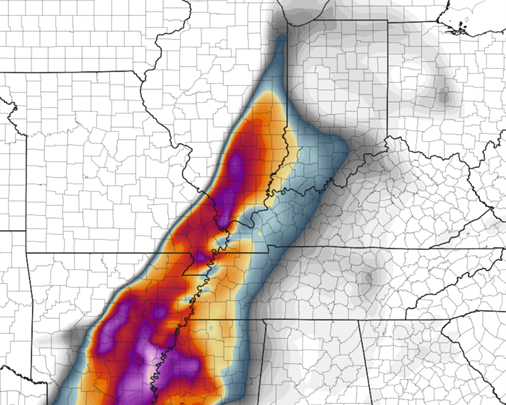
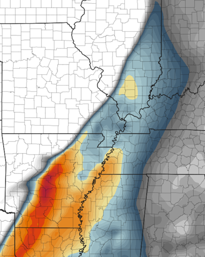
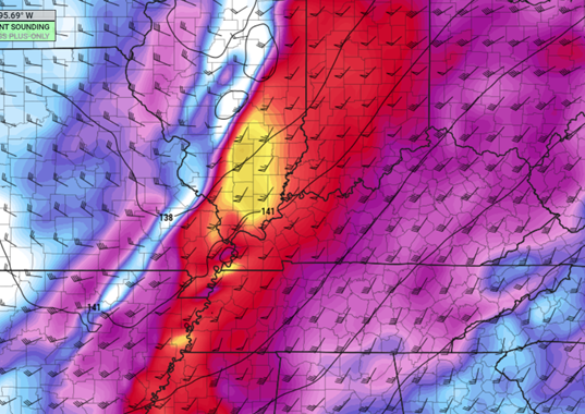
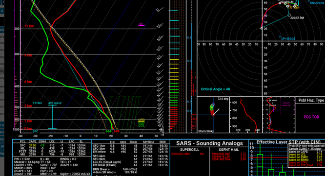
Not much has actually changed since my post a few days ago regarding the areas that will be targeted most with this event, although some specifics have changed! Generally, multiple rounds of thunderstorms will be possible throughout the day, mostly area from the most at risk area, throughout Illinois. Some of these will be severe and all threats will be possible, but threats are lower than areas near the Ohio/Mississippi River confluence and south that will be at a more heightened risk later this afternoon and throughout the evening. It is all dependent on morning development from southern Missouri and the western half of Arkansas. This will set the stage of where gets the ample heating, instability, and in general best environments later this afternoon. At the moment, the HRRR shows much more development this morning leading to a more southern, but heightened threat later this afternoon across the "moderate" areas in my outlook below. The NAM has a more scattered, but yet less development route with this event having a more spread out severe risk throughout the risk area, but the highest risk areas being in the "minor" risk area in the outlook below. This will mostly evolve has a more linear storm mode with embedded supercells and circulations, but as always with these event there will likely be renegade supercells in front of this line, and typically these have the risk for the strongest tornadoes. The timings below are very broad due to the multiple rounds of thunderstorms likely, although the latter part of the timings listed are the key times for these areas for the strongest weather. Nonetheless strong to significant severe weather will be possible throughout the day today, especially 3pm-10pm in the moderate risk area and the areas nearby. Mostly a damaging winds and tornado threat, although hail is also likely. Good afternoon everyone! It has been awhile since any severe weather has been possible throughout the region! The next FOUR days there are chances of severe weather throughout the Midwest. ESPECIALLY Tuesday Night and Wednesday!!! The situation for Tuesday and Wednesday will become more clear as the actual short-term models are available (HRRR/RAP/ 3k NAM, etc.) starting tomorrow morning and will plan on a post with updates sometime tomorrow afternoon around this time as well, and days to follow! Stay tuned! Sunday Night: There is a small disturbance to our north that could bring severe weather to the lower Midwest, especially the Ozarks region during the overnight hours tonight. Minimal wind shear will be in place, but due to the late arrival of ample moisture (55-60 dewpoints) and ample cape (1500-2000) cape, some severe weather will be possible starting just around and after sunset! It appears that this will be a higher end damaging wind and (especially) hail threat, and a lower tornado threat, but all threats are possible! My outlook is below, some storms could be continuing in the eastern portion of this section in the morning hours tomorrow! Monday: Monday's main threat will shift slightly south of tonight's threat, even though the disturbance moves off to the northeast. Some low-end severe weather (mostly damaging winds) will be possible in Southern Illinois and areas just to the south, especially in the afternoon/evening, but largely the main focus will be parts of Arkansas (for now). The HRRR has a more significant upper level jet-streak in place that will help facilitate storms over Arkansas, whereas the NAM does not have this in place and has very little development over this region. This will likely change and trends may favor one model or the other, but in this case at the moment I am leaning more with the HRRR with this situation. If this occurs, numerous supercells will form over Arkansas. I will assess this threat more tomorrow when it becomes more clear but at the moment this seems possible! This will be a mostly large hail threat with some tornado and damaging wind threat. There is more directional shear than speed shear in place for this event, which may have a small, but not a significant impact for the chances of tornadoes! This will unfold between 5-10pm tomorrow across Arkansas (if it does occur)! Tuesday and Tuesday night: Now for the most heightened severe events this week and ones that are actually over our region! Significant weather could be possible, especially Tuesday Night across parts of the middle Missouri River valley in parts of Nebraska, Iowa, Kansas, Missouri, and surrounding areas. There is still some uncertainty and timing of this whole event. The GFS and short term models appear to show a quicker system, more or less potentially affecting Wednesday's set up but may have an effect on Tuesday's as well (we will see tomorrow), but the Euro/Canadian/NAM show a slightly slower system which at the moment is a more clear situation. Although a most of the ingredients, especially across the areas I mentioned above, all come together very well, it appears that a strong capping inversion will be in place that would hinder the development of storms across this region, at least early on. As soon as this gets depleted, the storms should become very intense and severe in this region, due to high instability, wind shear, and moisture. Still a lot of uncertainties with this event so more will become clear over the next 24 hours, just a general idea of what areas should be most alert at the current time! Wednesday's threat: No time for the threat that will be actually threatening to our region, Central Illinois, and the most heightened risk for Central Illinois this year! Like Tuesday's situation, the models differ on timing of the system, so this will be subject to change, but due to model trends, especially the EURO and NAM models, it appears that this could potentially be more active than Tuesday's event, we shall see! Nonetheless, severe to possible significant weather will be possible throughout the Mississippi River to Ohio River valleys, likely reaching up to the lower Great Lakes. Some storms could be continuing from the morning so there could even be a lower severe weather threat across Iowa and Missouri, although it appears storms will start forming during the early afternoon across areas along the Mississippi River from Missouri and north, as it seems so far that these will initiate first, then more to the south alter in the afternoon. The timing is all important with this set up. It appears strong to significant wind shear will be likely, stronger instability (especially Southern Illinois and south), high dewpoints, and little to no capping layers to inhabit storm growth will all be in place. As details become more clear I will update and make changes to the forecast, although at the current time this is my (bold) forecast for a severe weather outlook for Wednesday and into Wednesday Night (below). Thanks guys and stay tuned as always! Significant Tornado Parameter NAM 7pm Wednesday CAPE (instability) NAM 7pm Wednesday 850mb winds (very strong) NAM 7pm Wednesday Forecast weather sounding from Marion County IL at 7pm on Wednesday.
Some general stuff to look for in a weather sounding: The CAPE (instability) is the area between the parcel temperature (white dotted line) and solid red line (air temperature) as it goes up into the atmosphere (the "850" to "700" and other numbers on the far left side indicate levels of the atmosphere). As you can see here, there is a large area between these two line, indicating high amounts of instability (the atmosphere is more unstable, more capable in producing more significant weather). When there is a temperature inversion in the lower levels (so bottom of the graph), as discussed with Tuesday's set up, where the temperature line goes to the right instead of left (temperatures get warmer), that indicates a cap, a limiting agent in storm development, a stable area of air in the atmosphere. In big severe weather events, there is large instability available, and when those two lines are closer together, these is less instability, or none at all (the instability value is the number next to the "ML" label (mixed-layer) in the bottom left portion of the picture. One can also see the ground temp and dewpoint (68 for temp and 66 for dewpoint). Another important feature is the hodograph, in the top right, which is essentially a graph of the winds in the atmosphere. One more significant days, I like to see more of a hook appearance on the hodograph, which this is close to showing! A more south to southeast surface flow (where the line starts at about 20kts from the south), and speed increases and becomes more westerly as the models looks higher up into the atmosphere, which this shows fairly well, getting MUCH stronger with a more southwesterly component in the mid to upper levels. If this is hard to understand, start with looking at the wind barbs in the right end of the temperature profile I first talked about and compare the two! The critical angle here is around 50, which is sufficient but would like an angle closer to 90 degrees (can explain this another time). 5:00am update:
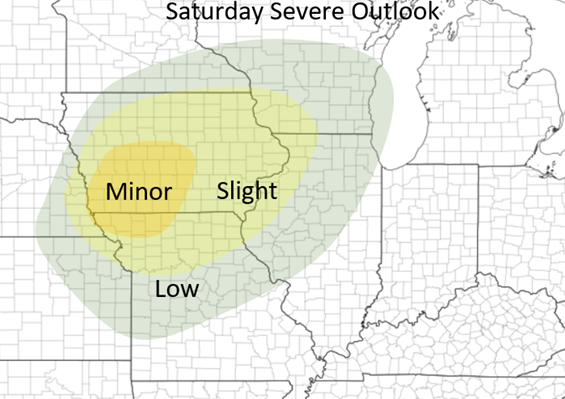
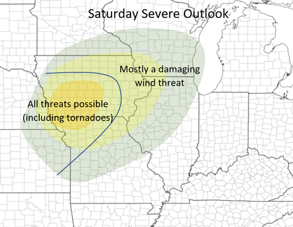
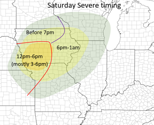
Good morning everyone! I hope everyone enjoys this beautiful, but windy day throughout Central Illinois! For my Iowa and nearby friends, it is looking like strong to severe storms will be possible throughout the state during the afternoon and into the evening! Worst timing: 3-7pm Threats: Damaging Winds, Hail, and a few tornadoes Main area of concern: Southwest into Central Iowa The deepening surface low is expected to slowly move across the Missouri River during the mid-afternoon hours into Iowa, bringing within the chance of severe weather ahead of it throughout parts of Iowa, Northern Missouri, and areas beyond. There appears to be some storms possibly as early as noon along and near I80 along and near the advancing warm front but the main focus will be from 3-7 pm between Des Moines Iowa and Omaha Nebraska. A very narrow corridor of barely sufficient CAPE (instability) will set up just in front of the advancing dryline correlated with the system (x>1,000). The lower to mid-level winds will strengthen during the afternoon creating a stronger speed and directional shear with mid-level winds becoming more southwesterly by late afternoon. Dewpoints are also expected to reach at least the upper 50s, if not barely peak above 60 just ahead of the dry line. With all of these, this makes this event possible over this region. There are still some discrepancies between the HRRR/RAP and the NAM, with the NAM showing a slightly less ample atmosphere ahead of the system but either way, severe weather will be possible in this region The maps for my forecast outlook, threats, and timings are below. Hint at the more heightened area I highlighted in southwestern and central Iowa. At the CURRENT time this is what appears to be the area at highest risk! Stay tuned! I will post updates if needed! Good afternoon everyone! Here is a brief update regarding today's weather, sorry this is late I had a busy morning!
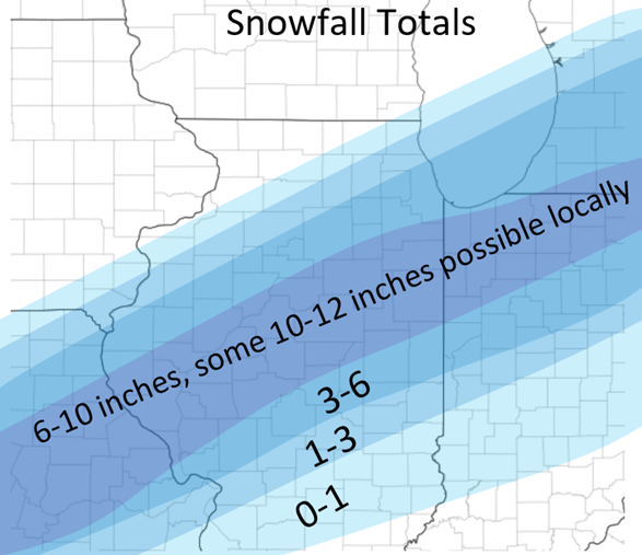
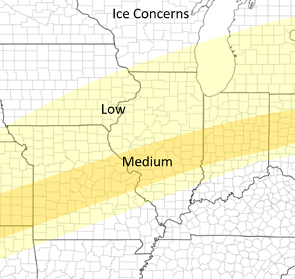
Here in Champaign it is currently a Freezing Rain/Sleet mix, and this should continue to hold (change to sleet) for the next couple of hours before changing to mostly snow. The current snow/mix line is from a Hardin to Waverly to Clinton to Gilman line and north, and this will continue to move slowly to the east throughout the day today, ending sometime during the late evening! Some ice has already accumulated here in Champaign and ice and sleet will continue to accumulate over the next couple hours here and areas to the south and east (see the areas in the "medium" ice risk from yesterday's map which I will attach below). Jacksonville: snowfall: 7-10 inches (all snow from now on ending around 7pm) heaviest snow: now-3pm Champaign: snowfall: 4-7 inches (generally 4-6), Mix/Sleet now-1:30pm, snow/mostly snow 1:30pm-8pm heaviest snow: 2-6pm Other area snowfall forecasts: Quincy: 5-8 Springfield: 6-9 Decatur: 4-7 Danville: 2-5 Bloomington: 7-11 Peoria: 5-8 Kankakee: 6-9 Other areas, see map below! Thanks and everyone stay safe! Good evening everyone! This is the second update regarding the weather within the next 24 hours across portions of Illinois. I will have the last main update sometime tomorrow morning! This post will also be relatively short. Generally, mostly rain (heavy at times) will cover Illinois during the nighttime hours tonight. This will start changing over to wintry precipitation from northwest (Quad Cities) to southeast overnight with by sunrise the freeze line being somewhere from a Hardin to Taylorville to Rantoul line and continue southeast throughout the day. Most areas above I70 will start as rain, then to freezing rain, then to sleet, and most will change over to snow during the day on Thursday. The first round is almost completely rain (ending around sunrise in Central Illinois) with the second round being mostly wintry precipitation starting around mid-morning. This will taper off from west to east during the evening hours on Thursday and will be completely done by at least midnight, if not as early as 9pm! Jacksonville: Snowfall: 6-9 inches Timing: Rain from now until 6am, Wintry mix (ice or sleet) 6-10am, Snow from 10/11am until 7/8pm Heaviest snow: 10:30-3:30pm Champaign: Snowfall: 4-7 inches Timing: Rain from now until 8am, Wintry Mix (ice or sleet) 8-1/2pm, Snow from 1/2pm-9pm Heaviest snow: 1:30-6pm Here are some forecasts at the current time: Some other thoughts and concerns:
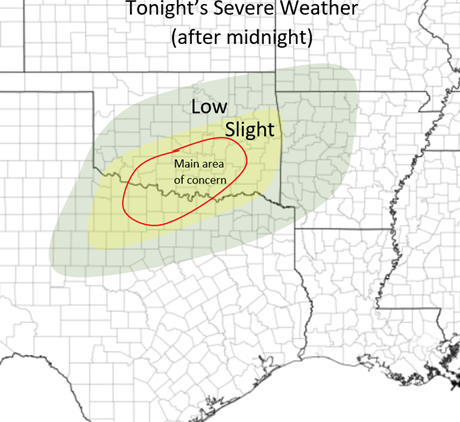
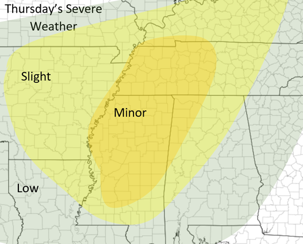
Flooding: Flash flooding is possible to likely throughout the state of Illinois throughout this event, especially south of I72. 1-2.5(+?) inches of rain will fall in these areas on top of mostly frozen soil so much of this will runoff into ditches and streams causing the possibilities of some flash flooding! Strong winds (brief blizzard-like conditions): This system will also bring very strong wind gusts along with it (35-45moh gusts at times tomorrow afternoon, especially along and near the I72 corridor). Besides 1-2 inch per hour the snow rates, this wind coupled with this is showing signs of possible blizzard conditions tomorrow afternoon so stay alert! Sleet mixing with snow: A lot of the wintry mix appears likely that it will mostly fall as sleet at the current time. This will limit some of the snowfall estimates along and near the I72 corridor. Sudden shifts in the track of the system can mean very stark differences in snowfall in parts of this area with sharp snowfall gradients. If the sleet stays more north and over a longer period of time, expect snowfall to be on the lower side and the opposite case would result in most snow along areas along I72. At the moment the I72 corridor seems to be the cut off area for this. Severe Weather: There is Severe Weather expected throughout the Southern Plains (tonight) and throughout the Mid-South during the day tomorrow. Despite strong to very strong wind shear, lower CAPE values are limiting the development of a potential outbreak scenario. Nonetheless, severe weather, including a couple tornadoes, is expected over the next 24-30 hours (see maps below)! Thanks and this is all for now! I hopefully will have a slightly more detailed post in the morning but ran out of time tonight! Stay tuned! |
Details
AuthorWrite something about yourself. No need to be fancy, just an overview. Archives
January 2024
Categories |
 RSS Feed