|
Good afternoon everyone! Here is a brief update regarding today's weather, sorry this is late I had a busy morning! Here in Champaign it is currently a Freezing Rain/Sleet mix, and this should continue to hold (change to sleet) for the next couple of hours before changing to mostly snow. The current snow/mix line is from a Hardin to Waverly to Clinton to Gilman line and north, and this will continue to move slowly to the east throughout the day today, ending sometime during the late evening! Some ice has already accumulated here in Champaign and ice and sleet will continue to accumulate over the next couple hours here and areas to the south and east (see the areas in the "medium" ice risk from yesterday's map which I will attach below). Jacksonville: snowfall: 7-10 inches (all snow from now on ending around 7pm) heaviest snow: now-3pm Champaign: snowfall: 4-7 inches (generally 4-6), Mix/Sleet now-1:30pm, snow/mostly snow 1:30pm-8pm heaviest snow: 2-6pm Other area snowfall forecasts: Quincy: 5-8 Springfield: 6-9 Decatur: 4-7 Danville: 2-5 Bloomington: 7-11 Peoria: 5-8 Kankakee: 6-9 Other areas, see map below! Thanks and everyone stay safe! 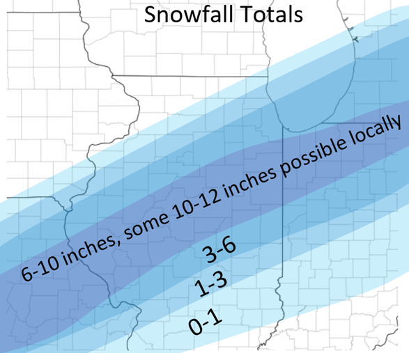 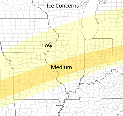
0 Comments
Leave a Reply. |
AuthorWrite something about yourself. No need to be fancy, just an overview. Archives
January 2024
Categories |
 RSS Feed