|
Good evening everyone! This is the second update regarding the weather within the next 24 hours across portions of Illinois. I will have the last main update sometime tomorrow morning! This post will also be relatively short. Generally, mostly rain (heavy at times) will cover Illinois during the nighttime hours tonight. This will start changing over to wintry precipitation from northwest (Quad Cities) to southeast overnight with by sunrise the freeze line being somewhere from a Hardin to Taylorville to Rantoul line and continue southeast throughout the day. Most areas above I70 will start as rain, then to freezing rain, then to sleet, and most will change over to snow during the day on Thursday. The first round is almost completely rain (ending around sunrise in Central Illinois) with the second round being mostly wintry precipitation starting around mid-morning. This will taper off from west to east during the evening hours on Thursday and will be completely done by at least midnight, if not as early as 9pm! Jacksonville: Snowfall: 6-9 inches Timing: Rain from now until 6am, Wintry mix (ice or sleet) 6-10am, Snow from 10/11am until 7/8pm Heaviest snow: 10:30-3:30pm Champaign: Snowfall: 4-7 inches Timing: Rain from now until 8am, Wintry Mix (ice or sleet) 8-1/2pm, Snow from 1/2pm-9pm Heaviest snow: 1:30-6pm Here are some forecasts at the current time: 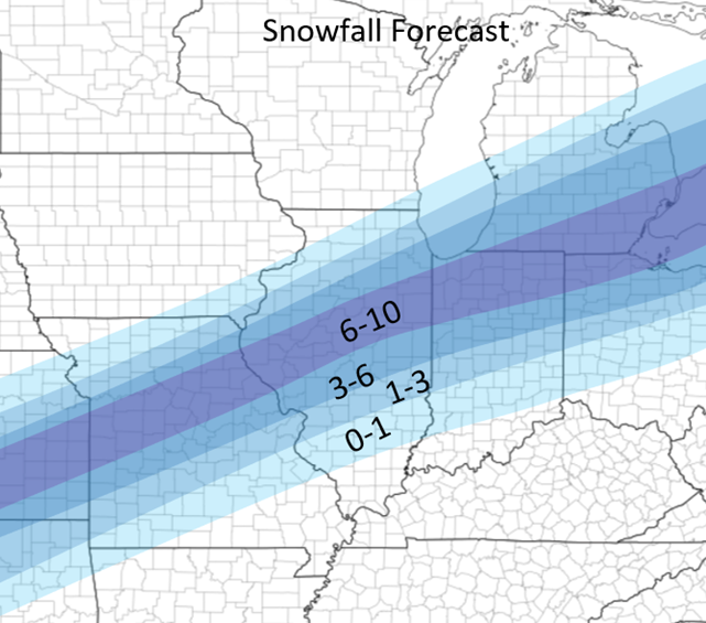 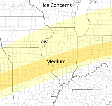 Some other thoughts and concerns: Flooding: Flash flooding is possible to likely throughout the state of Illinois throughout this event, especially south of I72. 1-2.5(+?) inches of rain will fall in these areas on top of mostly frozen soil so much of this will runoff into ditches and streams causing the possibilities of some flash flooding! Strong winds (brief blizzard-like conditions): This system will also bring very strong wind gusts along with it (35-45moh gusts at times tomorrow afternoon, especially along and near the I72 corridor). Besides 1-2 inch per hour the snow rates, this wind coupled with this is showing signs of possible blizzard conditions tomorrow afternoon so stay alert! Sleet mixing with snow: A lot of the wintry mix appears likely that it will mostly fall as sleet at the current time. This will limit some of the snowfall estimates along and near the I72 corridor. Sudden shifts in the track of the system can mean very stark differences in snowfall in parts of this area with sharp snowfall gradients. If the sleet stays more north and over a longer period of time, expect snowfall to be on the lower side and the opposite case would result in most snow along areas along I72. At the moment the I72 corridor seems to be the cut off area for this. Severe Weather: There is Severe Weather expected throughout the Southern Plains (tonight) and throughout the Mid-South during the day tomorrow. Despite strong to very strong wind shear, lower CAPE values are limiting the development of a potential outbreak scenario. Nonetheless, severe weather, including a couple tornadoes, is expected over the next 24-30 hours (see maps below)! Thanks and this is all for now! I hopefully will have a slightly more detailed post in the morning but ran out of time tonight! Stay tuned! 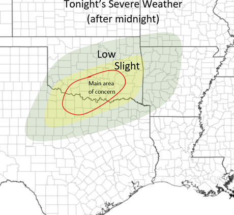 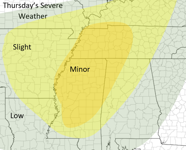
0 Comments
Leave a Reply. |
AuthorWrite something about yourself. No need to be fancy, just an overview. Archives
January 2024
Categories |
 RSS Feed