|
Good morning everyone, here's to the first very active day of 2022 throughout our region!
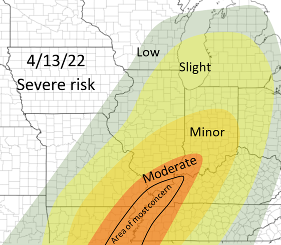
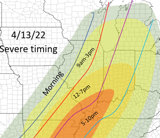
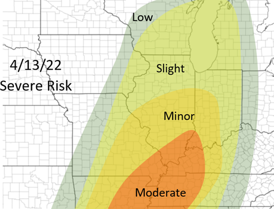
Not much has actually changed since my post a few days ago regarding the areas that will be targeted most with this event, although some specifics have changed! Generally, multiple rounds of thunderstorms will be possible throughout the day, mostly area from the most at risk area, throughout Illinois. Some of these will be severe and all threats will be possible, but threats are lower than areas near the Ohio/Mississippi River confluence and south that will be at a more heightened risk later this afternoon and throughout the evening. It is all dependent on morning development from southern Missouri and the western half of Arkansas. This will set the stage of where gets the ample heating, instability, and in general best environments later this afternoon. At the moment, the HRRR shows much more development this morning leading to a more southern, but heightened threat later this afternoon across the "moderate" areas in my outlook below. The NAM has a more scattered, but yet less development route with this event having a more spread out severe risk throughout the risk area, but the highest risk areas being in the "minor" risk area in the outlook below. This will mostly evolve has a more linear storm mode with embedded supercells and circulations, but as always with these event there will likely be renegade supercells in front of this line, and typically these have the risk for the strongest tornadoes. The timings below are very broad due to the multiple rounds of thunderstorms likely, although the latter part of the timings listed are the key times for these areas for the strongest weather. Nonetheless strong to significant severe weather will be possible throughout the day today, especially 3pm-10pm in the moderate risk area and the areas nearby. Mostly a damaging winds and tornado threat, although hail is also likely.
0 Comments
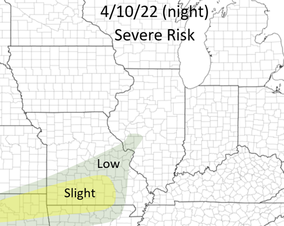
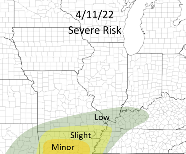
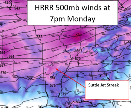
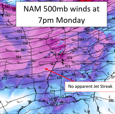
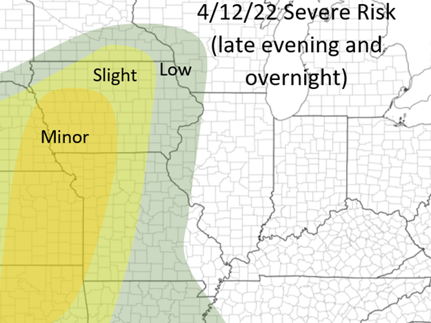
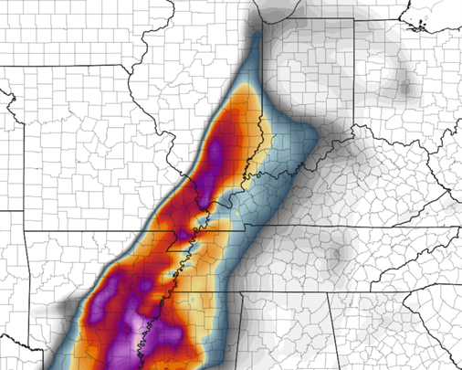
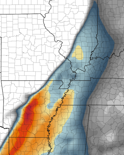
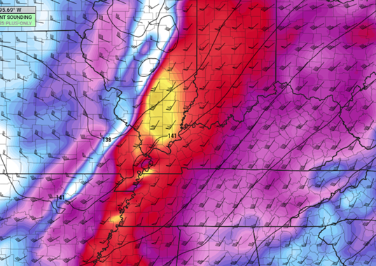
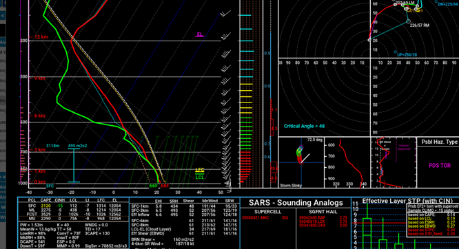
Good afternoon everyone! It has been awhile since any severe weather has been possible throughout the region! The next FOUR days there are chances of severe weather throughout the Midwest. ESPECIALLY Tuesday Night and Wednesday!!! The situation for Tuesday and Wednesday will become more clear as the actual short-term models are available (HRRR/RAP/ 3k NAM, etc.) starting tomorrow morning and will plan on a post with updates sometime tomorrow afternoon around this time as well, and days to follow! Stay tuned! Sunday Night: There is a small disturbance to our north that could bring severe weather to the lower Midwest, especially the Ozarks region during the overnight hours tonight. Minimal wind shear will be in place, but due to the late arrival of ample moisture (55-60 dewpoints) and ample cape (1500-2000) cape, some severe weather will be possible starting just around and after sunset! It appears that this will be a higher end damaging wind and (especially) hail threat, and a lower tornado threat, but all threats are possible! My outlook is below, some storms could be continuing in the eastern portion of this section in the morning hours tomorrow! Monday: Monday's main threat will shift slightly south of tonight's threat, even though the disturbance moves off to the northeast. Some low-end severe weather (mostly damaging winds) will be possible in Southern Illinois and areas just to the south, especially in the afternoon/evening, but largely the main focus will be parts of Arkansas (for now). The HRRR has a more significant upper level jet-streak in place that will help facilitate storms over Arkansas, whereas the NAM does not have this in place and has very little development over this region. This will likely change and trends may favor one model or the other, but in this case at the moment I am leaning more with the HRRR with this situation. If this occurs, numerous supercells will form over Arkansas. I will assess this threat more tomorrow when it becomes more clear but at the moment this seems possible! This will be a mostly large hail threat with some tornado and damaging wind threat. There is more directional shear than speed shear in place for this event, which may have a small, but not a significant impact for the chances of tornadoes! This will unfold between 5-10pm tomorrow across Arkansas (if it does occur)! Tuesday and Tuesday night: Now for the most heightened severe events this week and ones that are actually over our region! Significant weather could be possible, especially Tuesday Night across parts of the middle Missouri River valley in parts of Nebraska, Iowa, Kansas, Missouri, and surrounding areas. There is still some uncertainty and timing of this whole event. The GFS and short term models appear to show a quicker system, more or less potentially affecting Wednesday's set up but may have an effect on Tuesday's as well (we will see tomorrow), but the Euro/Canadian/NAM show a slightly slower system which at the moment is a more clear situation. Although a most of the ingredients, especially across the areas I mentioned above, all come together very well, it appears that a strong capping inversion will be in place that would hinder the development of storms across this region, at least early on. As soon as this gets depleted, the storms should become very intense and severe in this region, due to high instability, wind shear, and moisture. Still a lot of uncertainties with this event so more will become clear over the next 24 hours, just a general idea of what areas should be most alert at the current time! Wednesday's threat: No time for the threat that will be actually threatening to our region, Central Illinois, and the most heightened risk for Central Illinois this year! Like Tuesday's situation, the models differ on timing of the system, so this will be subject to change, but due to model trends, especially the EURO and NAM models, it appears that this could potentially be more active than Tuesday's event, we shall see! Nonetheless, severe to possible significant weather will be possible throughout the Mississippi River to Ohio River valleys, likely reaching up to the lower Great Lakes. Some storms could be continuing from the morning so there could even be a lower severe weather threat across Iowa and Missouri, although it appears storms will start forming during the early afternoon across areas along the Mississippi River from Missouri and north, as it seems so far that these will initiate first, then more to the south alter in the afternoon. The timing is all important with this set up. It appears strong to significant wind shear will be likely, stronger instability (especially Southern Illinois and south), high dewpoints, and little to no capping layers to inhabit storm growth will all be in place. As details become more clear I will update and make changes to the forecast, although at the current time this is my (bold) forecast for a severe weather outlook for Wednesday and into Wednesday Night (below). Thanks guys and stay tuned as always! Significant Tornado Parameter NAM 7pm Wednesday CAPE (instability) NAM 7pm Wednesday 850mb winds (very strong) NAM 7pm Wednesday Forecast weather sounding from Marion County IL at 7pm on Wednesday.
Some general stuff to look for in a weather sounding: The CAPE (instability) is the area between the parcel temperature (white dotted line) and solid red line (air temperature) as it goes up into the atmosphere (the "850" to "700" and other numbers on the far left side indicate levels of the atmosphere). As you can see here, there is a large area between these two line, indicating high amounts of instability (the atmosphere is more unstable, more capable in producing more significant weather). When there is a temperature inversion in the lower levels (so bottom of the graph), as discussed with Tuesday's set up, where the temperature line goes to the right instead of left (temperatures get warmer), that indicates a cap, a limiting agent in storm development, a stable area of air in the atmosphere. In big severe weather events, there is large instability available, and when those two lines are closer together, these is less instability, or none at all (the instability value is the number next to the "ML" label (mixed-layer) in the bottom left portion of the picture. One can also see the ground temp and dewpoint (68 for temp and 66 for dewpoint). Another important feature is the hodograph, in the top right, which is essentially a graph of the winds in the atmosphere. One more significant days, I like to see more of a hook appearance on the hodograph, which this is close to showing! A more south to southeast surface flow (where the line starts at about 20kts from the south), and speed increases and becomes more westerly as the models looks higher up into the atmosphere, which this shows fairly well, getting MUCH stronger with a more southwesterly component in the mid to upper levels. If this is hard to understand, start with looking at the wind barbs in the right end of the temperature profile I first talked about and compare the two! The critical angle here is around 50, which is sufficient but would like an angle closer to 90 degrees (can explain this another time). |
Details
AuthorWrite something about yourself. No need to be fancy, just an overview. Archives
January 2024
Categories |
 RSS Feed