|
Good morning guys! This is the main official post regard the snow for today and tonight here in IL. Nothing has really changed since my last post. Generally, 1-3 inches of snow fell in most of IL last night. The main round of snow is still to come! The snow is starting to push north into Southern IL as of 9am this morning. This will continue to push north to northeast as the day progresses. Below I will have a storm timing of snow map below: 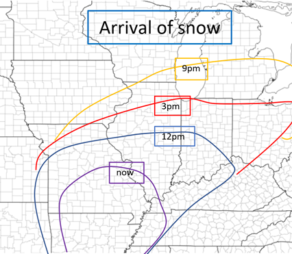 Next, I will have a timing of when the heaviest snow will fall during this event. This map is below: 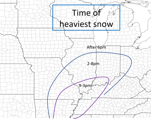 NOW, time for the snowfall forecast. Generally not much has changed since last night's forecast. I am going a little bullish, especially with the 10-14, but latest models suggest that this is possible/likely. We shall see! 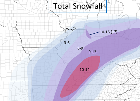 All for now! Stay tuned for Wednesday/Thursday's system. The latest NAM suggests 4-8 inches for central IL Wednesday-Thursday. Stay tuned!
0 Comments
Good afternoon guys! This is my first post over the system that will be coming into our region early this week. In the last 24 hours there has been a huge shift in snowfall totals with this system on the "up" trend. If someone asked be 24 hours ago, I would have said Champaign would get 4-6 from this, now we are possibly going to receive 9-12 from this system. A big change! We are going to see one minor round of snow with this system and one major round of snow. The minor round of snow will occur Sunday night, which will start after dusk in IL and will mostly move out by daylight from west to east. Generally 1-4 with this round in central and southern IL. Here's a map of the snow at Midnight Monday morning AND the snowfall forecast for Sunday night. Keep in mind, any "Day/night" snowfall forecasts are 12 hour periods. So, Day forecasts are 6am-6pm and night forecasts are 6pm-6am! 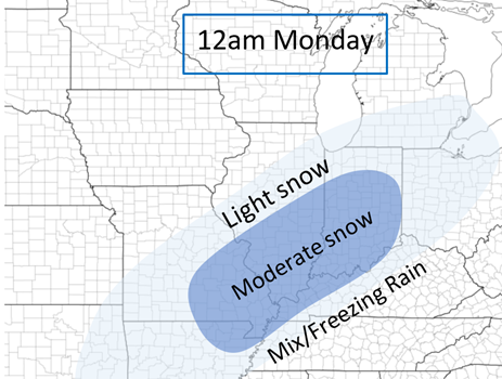 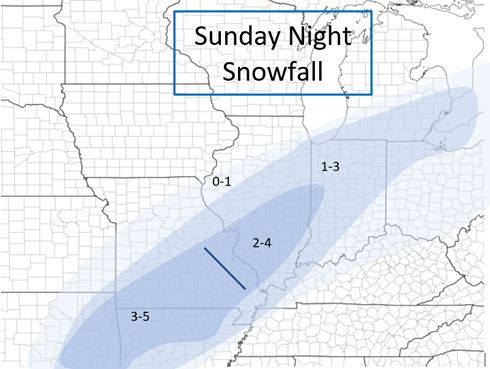 Now, for the main round of snow: Monday and Monday Night. Forecasts are expected to change but this is based off where the situation stands as of now. There will be a break in snow Monday morning as the first road diminishes and continues to move to the east. The snow will start in extreme Southern IL late Monday morning and will continue to move north throughout the day. Very heavy snow can be expected with this round, especially in Southern and east-central IL. Below I will have Maps for noon and 6pm Monday as well as a snowfall forecast for Monday. 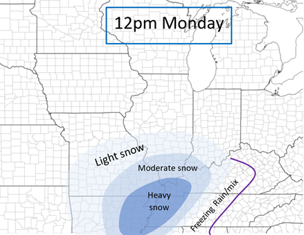 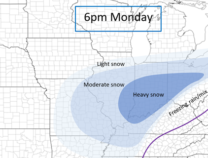 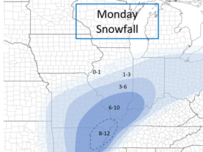 The heavy snow will continue to move to the northeast. The snow will eventually tapper off from southwest to northeast Monday Night and will be completely out of IL by 6am Tuesday. There's also a lake effect component for the Chicago Lakefront Monday Night so that is also something else to watch for. Below I will have a Midnight Tuesday morning map, Monday Night forecast, and a TOTAL Snowfall map in general from now until Tuesday. I will have another update Monday Morning! ALSO, another major system is coming into the Ohio River Valley/Southern App Mountains Wednesday night/Thursday and could bring several inches of snow again to the same areas this system is bringing snow to. Just a heads up! Thanks for reading! Stay tuned! 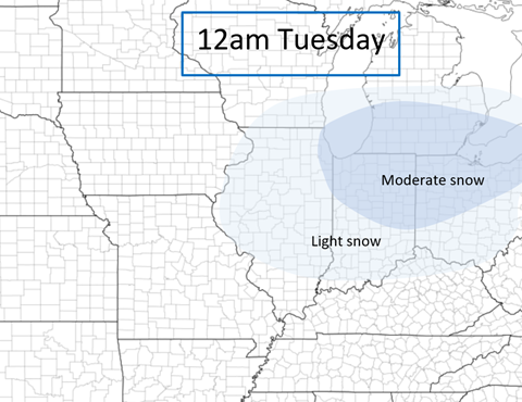 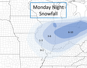 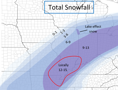 Good morning guys! This post will be talking about the few snow chances that we will be having in the next week PLUS new developments about the cold next week. First we have a system pushing into our region today (Thursday). Generally no snow south of I72 and most of the heaver snow (2-3+) will be north of I80, so nothing really for central IL. Precip types: It will be all rain (besides some light snow in the late afternoon) south of I72. It will be mostly rain with some snow at the end between I72 and I80. It will be all/mostly all snow north of I80 The snow will start in northwestern IL around 11 and will push its way East and will start in northeastern IL by 3pm. Generally, the snow will be done in western IL by 6pm and eastern IL by around 9pm. Snowfall Totals: I will have a snowfall map below but generally, 0-1 inches Highway 136 and south, 1-2 from Highway 136 to I80, 2-4 inches north of I80, and a small area of 4-6 in northwest IL. Although wind won't be a terribly big factor during the day today, although tonight, locations in Northern IL may see gusts 35-40+ mph so some blizzard conditions in those areas that received snow Thursday may see some possible blizzard conditions 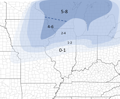 Snowfall for Thursday's system Next, we have two systems after that. One Saturday night and one early next week. We'll have a couple mini upper level troughs that will bring these small disturbances our way. Below I will have a rough snowfall forecast for Saturday's (evening/night) system, but too far out to tell about early next week's system but generally snow will be possible in the Mid-Mississippi River valley. 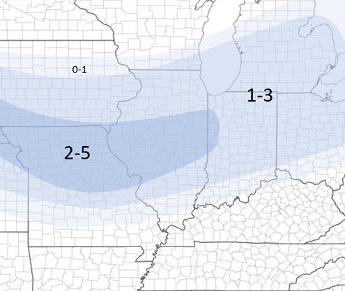 Saturday snowfall forecast NOW for the the cold weather next week.
Earlier this week, I had stated that some very cold weather was coming into IL early next week. Although that is still true, due to new disturbances, the cold is somewhat holding off until mid to late next week. After each system, there is another "punch" of cold air into our region. A semi-cold punch after today's system, a cold punch after Saturday's system (cold Sunday and semi-cold Monday), then very cold mid next week after the system early next week. Generally low temps below 0 and highs in the single digits here in central IL late next week. This is still developing, especially since the system early next week is still uncertain but either way we have some cold coming into IL finally next week! Stay tuned as always! |
AuthorWrite something about yourself. No need to be fancy, just an overview. Archives
January 2024
Categories |
 RSS Feed