|
Good morning everyone! Happy Saturday! It is COLD here in Jonesboro, but it is winter of course! Only a couple of months until actual warm weather! I'll be counting down to March after next week's weather! See below for a full discussion of the upcoming event, scroll down to see my snowfall forest as of 11am on Saturday. General Notes about the Setup of the Event: As some of you may know, we have a chance for snow (or at least here in northeast Arkansas) Sunday and Monday. This is an interesting setup. There is no actual system that this is tied to, or at least for here. A large band of snow will move out of the Rockies associated with a system in the west, but the short dip in the jet stream that caused the system falls apart, therefore leaving a band of snow that moves into the southern Midwest Sunday afternoon and into the night. This will be the heaviest snow for southern Missouri & northern Arkansas. Then a stronger dip in the jet stream develops Monday, in which a system starts to develop in the southeast. This causes a 'revamp' in wintery precipitation across the Lower Mississippi River Valley across LA, AR, MS, and western TN Monday morning and afternoon. More specially a band of stronger precipitation from S/C AR, W TN, and the northern half of MS that will move east throughout Monday afternoon. See below for the timing of the heaviest precipitation times for the event: 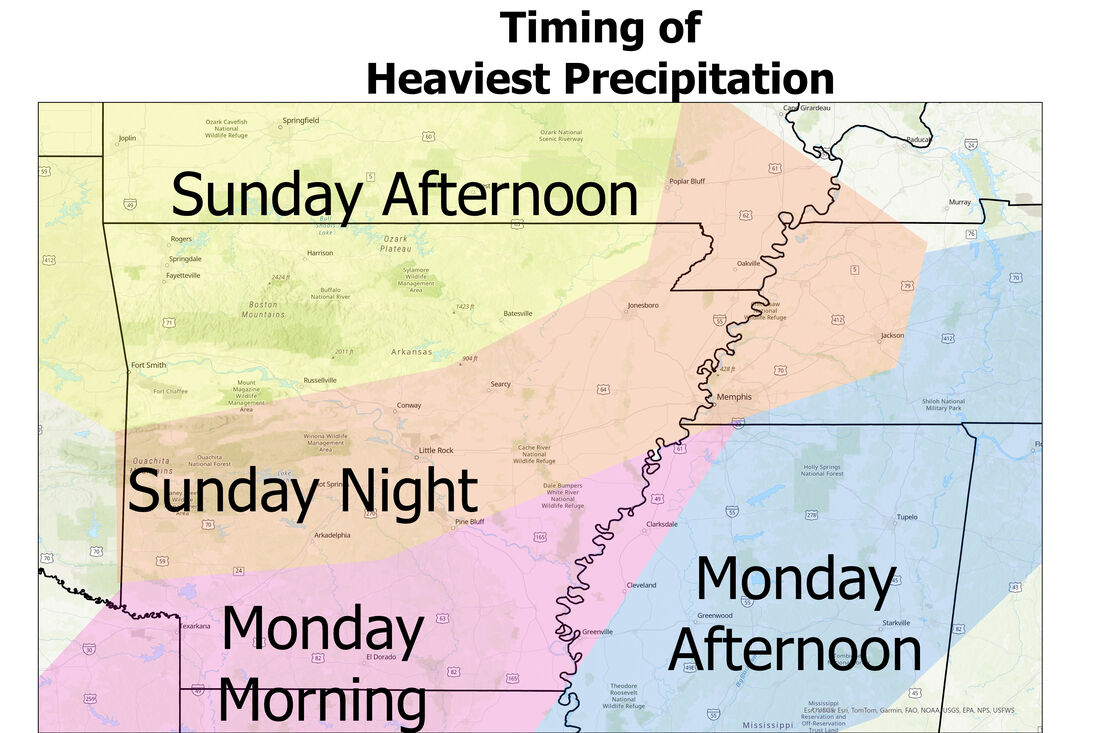 Precipitation Types: This is a hard to forecast for types of precipitation, especially for areas south of Interstate 40. The event will begin as all snow north of I40 Sunday afternoon and evening, but once the precipitation reaches the I40 corridor, most locations south have a large enough temperature inversion in the lower levels of the atmosphere to cause sleet to fall, and later even farther south freezing rain. The models vary between mostly sleet (HRRR) or mostly freezing rain (NAM) for the areas labeled as 'mix' in the below figure, but overall just know in the areas either labeled as Freezing Rain or Sleet, there will be a mix for most of the event (less than .25 of an inch for most of the region, especially in the western half). This is just my thought for now: 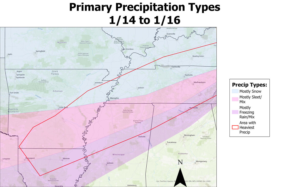 Snow Accumulation Forecast: Now for locations along and north of Interstate 40, there will be plenty of snow to come, although the models have varied all week with the totals. Even as of yesterday, some long-range models were throwing out 12-18 totals or 1-2 totals for northeast Arkansas. So far the short-range models have agreed with most locations receiving accumulations more in the middle, but I'll have a more detailed forecast with more specific amounts tomorrow morning (Sunday) as models become more accurate with the placement of the heaviest snow as well as how much. Overall, the heaviest snow will likely fall just north of this snow/sleet transition line along and north of Interstate 40 from Sunday night to early Monday afternoon, with break periods or lighter snow Monday morning as the precipitation ramps back up in the afternoon from Little Rock and east. See the map as for broad range amounts, but I have a few locations below for more specific information on how much to expect and when: ALL FORECASTS ARE SUBJECT TO CHANGE Jonesboro 2-5 inches Sunday Afternoon: None (flurries starting around sunset) Sunday Night: 1-3 inches Monday: Around 1 inch Heaviest Snow: 6pm-12am Sunday night Memphis: 5-8 inches Sunday Afternoon: None Sunday Night: 3-6 inches Monday: 1-3 inches Heaviest snow: 9pm-3am Sunday Night & 9am-3pm Monday (some may fall as sleet) Little Rock 2-5 inches Sunday Afternoon: None Sunday Night: 1-3 inches Monday: 1-2 inches Heaviest Snow: 9pm-3am Sunday Night Bentonville/Fayetteville: 3-6 inches Sunday Afternoon: 3-6 Inches Sunday Night/Monday: None Heaviest Snow: 12pm-6pm Sunday 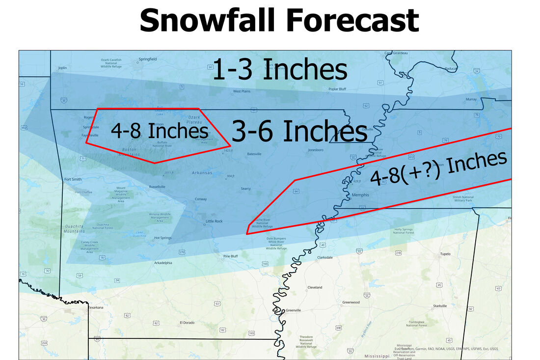 Thanks for reading and another update will be posted tomorrow morning around the same time (10/11am). This may all change, as weather models always throw something different right before any event, but nonetheless expect some snow and wintry precipitation throughout the Lower Mississippi River Valley! Also note extreme cold which arrives Sunday into Monday and lasts until Thursday throughout the region!
0 Comments
|
AuthorWrite something about yourself. No need to be fancy, just an overview. Archives
January 2024
Categories |
 RSS Feed