|
Good morning everyone! Today's risk the main focus will be across a large portion of Wisconsin, as well as Northeastern Iowa and Western Upper Peninsula of Michigan. All threats will be likely including a few tornadoes, some could be quite strong. The main timing of this event will be 2-8pm, although more of a damaging wind threat after 8 across portions of Eastern Wisconsin, Northern Illinois, and other parts of the Upper Peninsula of Michigan. Below I have my outlook and timing for the event today: 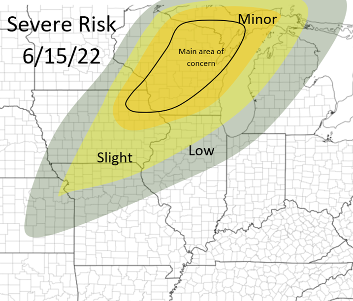 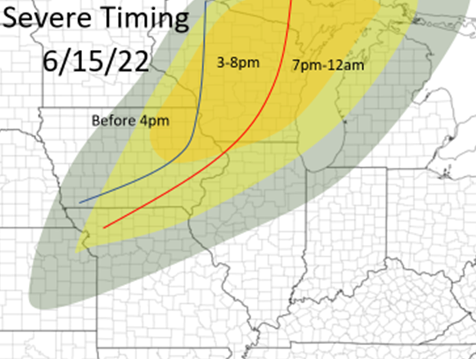 The storms will fire between 1-4pm over portions of Northeastern Iowa, far Southeastern Minnesota, and Western Wisconsin, and track northeast. The main tornado risk is earlier this evening, across portions of Iowa, Western and Northern half of Wisconsin (areas within the minor risk), and the Western Upper Peninsula of Michigan. CAPE values will be 2500+ across most of this area, the best shear will be across areas in Northern Wisconsin with a more southerly to southeasterly surface flow, although in areas with greater CAPE across all areas of southern Wisconsin (seen in picture below). There is also a slight concern about this morning convection coming out of Iowa by inhibit the extent or intensity of CAPE to Northern Wisconsin this afternoon. Early on in the afternoon should have enough shear to also pose a strong tornado threat as well in Southern Wisconsin, before winds become more southwesterly producing less ample wind shear for tornadic storms. After these storms move into Eastern Wisconsin this afternoon and nearby areas, the storms will become more linear in mode and pose a more damaging wind threat, although all threats can not be ruled out. All for now! Stay tuned for more! 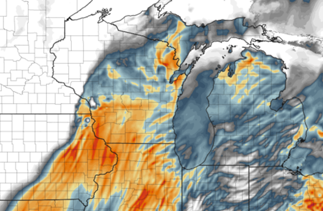 HRRR CAPE map from the afternoon, showing higher CAPE values in Southern Wisconsin but stronger wind shear will likely be across areas of Northern Wisconsin, but strong shear will be all throughout the threat area today 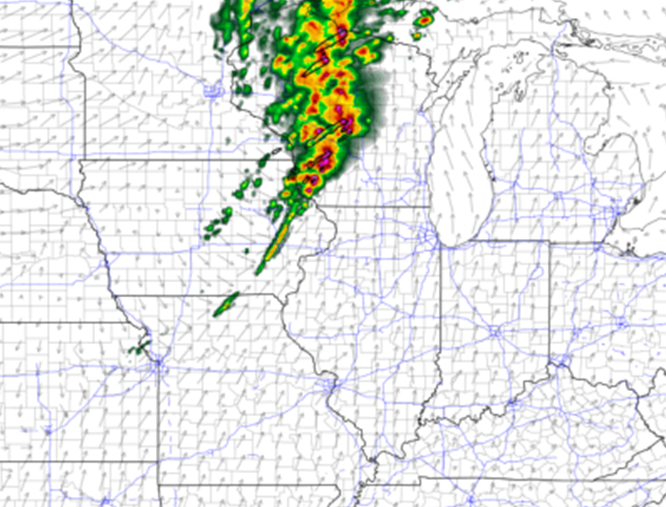 HRRR at 5pm, showing a line of storms erupting across Western and Central Wisconsin
0 Comments
Good morning everyone! I haven't talked about weather in a long time! This has been a more quiet spring for our region so far, although that is likely to change in the coming weeks! Today's threat will focus in the Eastern Midwest and into the Eastern Ohio River Valley throughout this afternoon. All threats will be likely with a few tornados possible, especially across Indiana and Western Ohio, but even at this time there are still some uncertainties. Nonetheless, all threats will be likely from Western Ohio and west, and areas to the east of Western Ohio it will be a more damaging wind threat. As of now, it appears storms will develop near the Illinois/Indiana border and areas nearby to the east. The HRRR is hinting at more development across the I74 corridor early on and a more messy set up along the advancing warm front. The NAM shows a more clean warm sector with storms forming along the Stateline and moving east. The important factors are the amount of wind shear and the amount of CAPE (instability) that will be in place ahead of this set up. Before I talk about the main models, I'll bring up 14z mesoscale analysis and the 6 hour forecast from this on the SPC website. This to me is showing a mix between the two models, suggesting CAPE values of 1000-1500+ will be in place near the target area by 4pm ET with ample wind shear getting in place by this time as well. 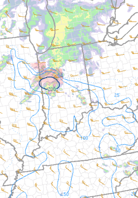 Mesoscale Analysis of Storm Relative Helicity at 4pm ET 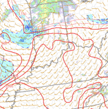 Mesoscale Analysis of CAPE at 4pm ET The main problem with the HRRR is showing the lack of low level winds, especially at around 850mb in the atmosphere. The NAM shows a very robust and strong 850mb jet over the target area, and slightly more southerly. The HRRR doesn't necessarily show a tightening low over Central Indiana by 5pm ET which makes the winds more out of the southwest, closer to the lower levels as well, along with the lack of stronger winds. Also, the HRRR shows slightly less instability than the NAM, correlating with a more messy set up and not as a clear atmosphere from this morning's convection. 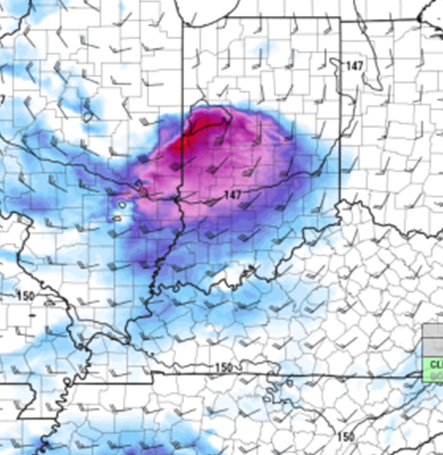 NAM 850mb winds at 3pm ET  HRRR 850mb winds at 3pm ET 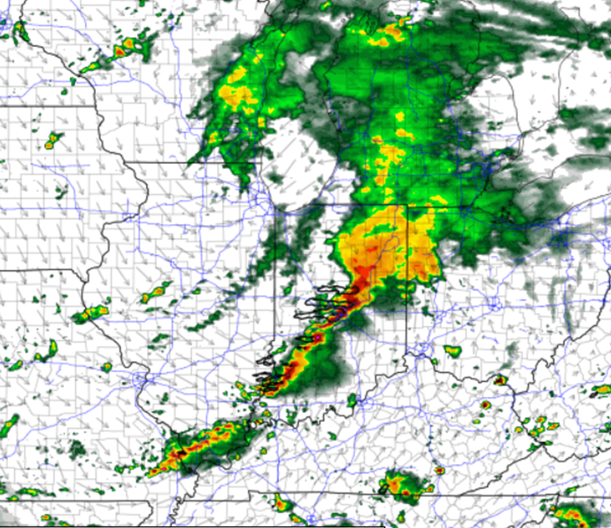 NAM at 5pm ET 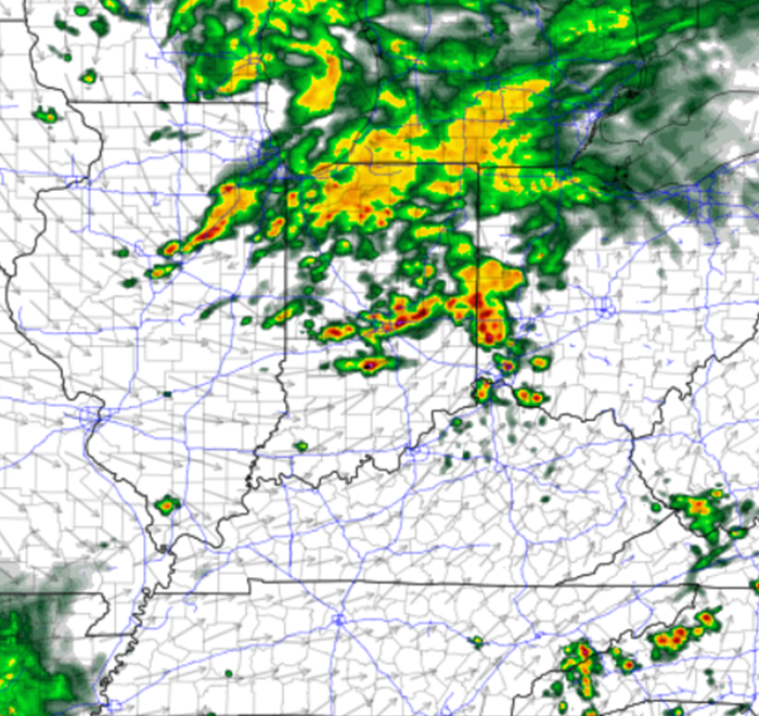 HRRR 5pm ET Nonetheless, severe weather will be likely across this area throughout this afternoon. Below I have an outlook I made for today along with general timings for the severe weather. I am a little bold with the outlook with including a "minor" risk although between the NAM and the mesoscale analysis I'm feeling more confident with this area being the focus area for severe weather today. I could be wrong, but we will see how today goes and I'll learn, weather is always changing! All for today! I am leaving to go chase for the first time in nearly a month! Stay tuned! 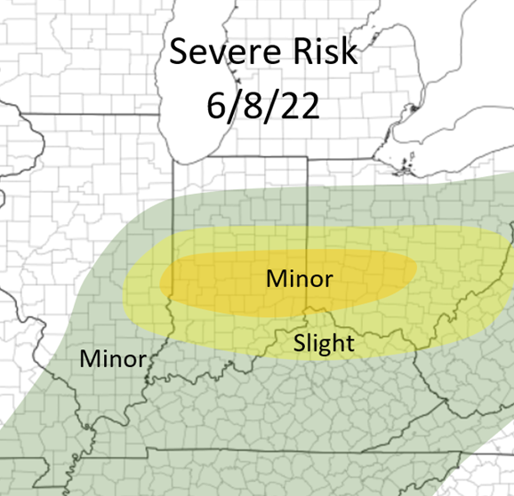 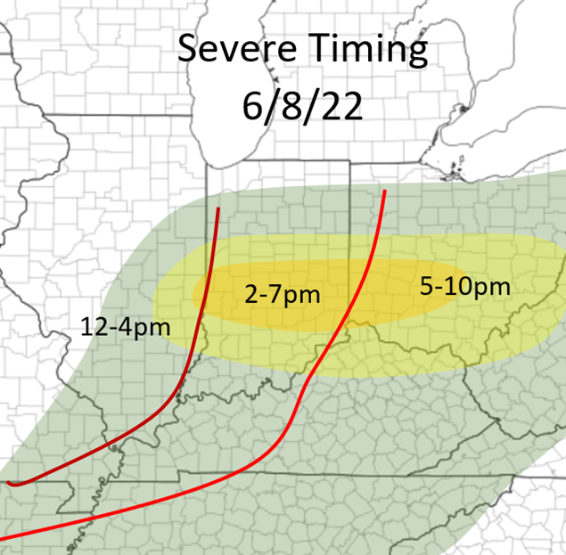 |
AuthorWrite something about yourself. No need to be fancy, just an overview. Archives
January 2024
Categories |
 RSS Feed