|
Good morning guys! This post will be talking about the few snow chances that we will be having in the next week PLUS new developments about the cold next week. First we have a system pushing into our region today (Thursday). Generally no snow south of I72 and most of the heaver snow (2-3+) will be north of I80, so nothing really for central IL. Precip types: It will be all rain (besides some light snow in the late afternoon) south of I72. It will be mostly rain with some snow at the end between I72 and I80. It will be all/mostly all snow north of I80 The snow will start in northwestern IL around 11 and will push its way East and will start in northeastern IL by 3pm. Generally, the snow will be done in western IL by 6pm and eastern IL by around 9pm. Snowfall Totals: I will have a snowfall map below but generally, 0-1 inches Highway 136 and south, 1-2 from Highway 136 to I80, 2-4 inches north of I80, and a small area of 4-6 in northwest IL. Although wind won't be a terribly big factor during the day today, although tonight, locations in Northern IL may see gusts 35-40+ mph so some blizzard conditions in those areas that received snow Thursday may see some possible blizzard conditions 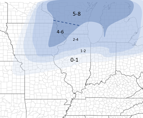 Snowfall for Thursday's system Next, we have two systems after that. One Saturday night and one early next week. We'll have a couple mini upper level troughs that will bring these small disturbances our way. Below I will have a rough snowfall forecast for Saturday's (evening/night) system, but too far out to tell about early next week's system but generally snow will be possible in the Mid-Mississippi River valley. 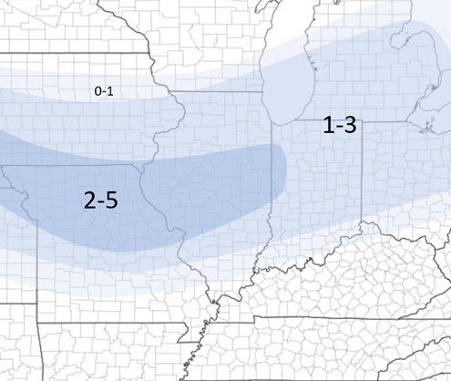 Saturday snowfall forecast NOW for the the cold weather next week.
Earlier this week, I had stated that some very cold weather was coming into IL early next week. Although that is still true, due to new disturbances, the cold is somewhat holding off until mid to late next week. After each system, there is another "punch" of cold air into our region. A semi-cold punch after today's system, a cold punch after Saturday's system (cold Sunday and semi-cold Monday), then very cold mid next week after the system early next week. Generally low temps below 0 and highs in the single digits here in central IL late next week. This is still developing, especially since the system early next week is still uncertain but either way we have some cold coming into IL finally next week! Stay tuned as always!
1 Comment
Jen Scoby
2/4/2021 07:36:35 am
Thanks - our fave forecast source - very helpful! Leave a Reply. |
AuthorWrite something about yourself. No need to be fancy, just an overview. Archives
January 2024
Categories |
 RSS Feed