|
Good morning everyone, here's to the first very active day of 2022 throughout our region! Not much has actually changed since my post a few days ago regarding the areas that will be targeted most with this event, although some specifics have changed! Generally, multiple rounds of thunderstorms will be possible throughout the day, mostly area from the most at risk area, throughout Illinois. Some of these will be severe and all threats will be possible, but threats are lower than areas near the Ohio/Mississippi River confluence and south that will be at a more heightened risk later this afternoon and throughout the evening. It is all dependent on morning development from southern Missouri and the western half of Arkansas. This will set the stage of where gets the ample heating, instability, and in general best environments later this afternoon. At the moment, the HRRR shows much more development this morning leading to a more southern, but heightened threat later this afternoon across the "moderate" areas in my outlook below. The NAM has a more scattered, but yet less development route with this event having a more spread out severe risk throughout the risk area, but the highest risk areas being in the "minor" risk area in the outlook below. This will mostly evolve has a more linear storm mode with embedded supercells and circulations, but as always with these event there will likely be renegade supercells in front of this line, and typically these have the risk for the strongest tornadoes. The timings below are very broad due to the multiple rounds of thunderstorms likely, although the latter part of the timings listed are the key times for these areas for the strongest weather. Nonetheless strong to significant severe weather will be possible throughout the day today, especially 3pm-10pm in the moderate risk area and the areas nearby. Mostly a damaging winds and tornado threat, although hail is also likely. 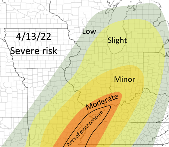 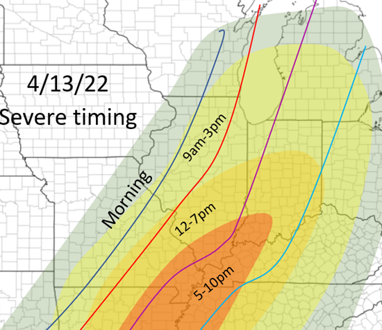
0 Comments
Leave a Reply. |
AuthorWrite something about yourself. No need to be fancy, just an overview. Archives
January 2024
Categories |
 RSS Feed