|
Good morning everyone! Who's ready for record warmth today in Eastern Illinois?! This warmth (highs in mid 60s) will also fuel an environment potentially favorable for severe weather this afternoon in portions of Southern and Eastern Illinois. All risks are possible including a tornado or two. This environment is marginally ample, meaning conditions are ample enough to produce a few supercells, but not ample enough for any significant event or development of storms. The main timing is from 1 to 6 pm, more particuarly 2 to 5 pm. Any storms will fire from near and just east of the STL metro area and will quickly move northeast. Below is a map of the target areas and after the map I explain the set up for today! 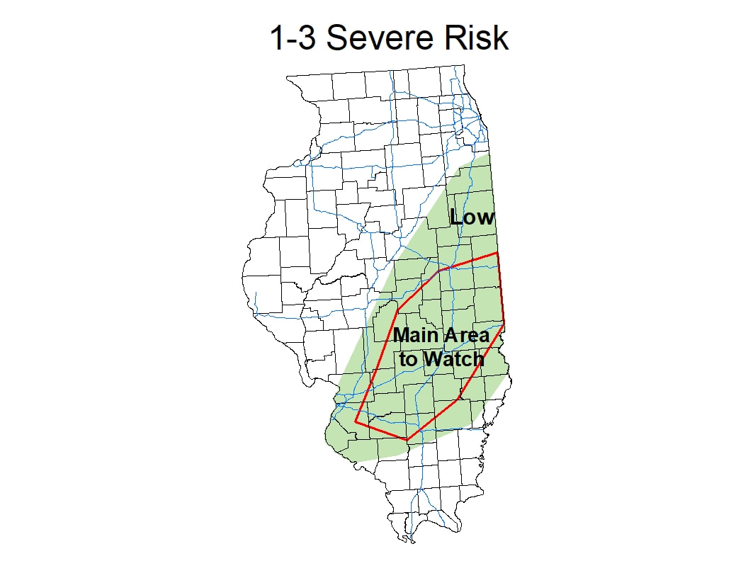 Environment for today: As stated before, this is a marginally ample environment. This is similar to a couple very active December events in Illinois over the past decade. A powerful system sits over or near Iowa, storms persist over the south, but a small area of favorable conditions forms near the low pressure over Illinois. Although instability is looking slightly more supportive over the last few hours, wind shear is not near strong enough to support a substantial tornado event like these prior events. There is still modest wind shear available today, with SRH values 150-200 across the region, more specifically along and near I70, but are modest wind shears with CAPE values 750-1250 (possibly breaking 1250). In order to see a small outbreak, SRH (wind shear) values would have to be closer to 300 with the lower CAPE values. Still, between the marginal instability and modest wind shear, severe weather is still possible across the region, mostly along the nose of the small warm section in front of the cold front. Below I have a few screenshots showing the instability and a few weather soundings with descriptions of what to look for in the captions! Thanks for reading and if anything significant changes I'll post again! 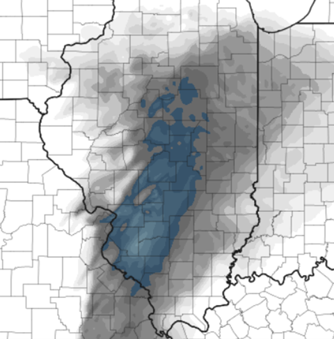 HRRR ML CAPE values at 2pm, the blue colors are CAPE values of greater than 1,000 and are ample enough to energize storms that develop. This corridor will move east throughout the afternoon. Generally for severe storm development, CAPE values of greater than 1,000 are needed. 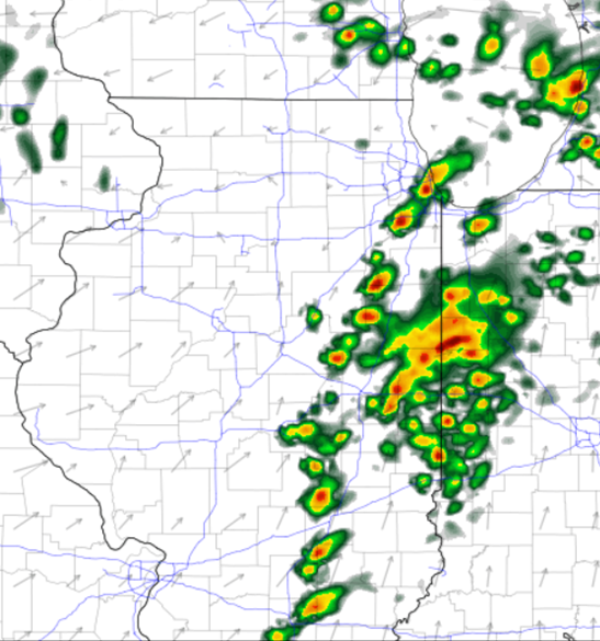 HRRR at 5pm (7am model) 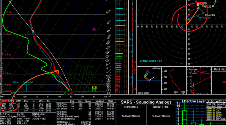 HRRR forecast weather sounding from Douglas County at 5pm. I circled the CAPE value (arrow pointing to how this value is calculated, the area between the temp and the dotted line (parcel temp) and the hodograph (wind shear). When looking at a hodograph, on favorable days, (simple explanation) the more hooked or curved the line on the graph is the more wind shear/ample for tornadoes. This hodograph is good (look at the third hodo for a much less favorable one) because surface winds are 10-15kts from the S and slightly higher up are 40kts from the SW, showing a curved appearance. This shows both speed and directional shear. Although stronger SW winds higher up and a more SE flow near the surface would be more favorable. 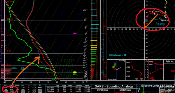 NAM over Randolph County at 2pm, showing slightly less favorable CAPE but a much more favorable hodograph. Even more curved than the one before, a hodograph like this is supportive for supercell development and tornadoes. 15kt S surface wind and 50kt SW wind towards the mid levels. 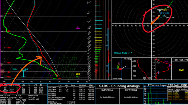 HRRR 4pm weather sounding from Ford County. Supportive CAPE values but the hodograph is much less favorable, nearly linear with SW or near SW winds at the surface and at mid levels. Need supportive CAPE values to co-locate with ample wind shear for the best potential!
0 Comments
Leave a Reply. |
AuthorWrite something about yourself. No need to be fancy, just an overview. Archives
January 2024
Categories |
 RSS Feed