|
This is the first update for the major system developing in the southern plains and rocketing across the Ohio River Valley mid to late this week! Major, possibly significant winter weather along with severe weather and flooding are all likely with this event! WINTER WEATHER: Generally, this event will start out as rain throughout the region during Wednesday afternoon and evening. Throughout the early morning and daylight morning hours Thursday north of I70, especially north of I72 earlier one, will change to wintry precipitation. Most of the precipitation will tapper out throughout Thursday evening and early night hours from west to east throughout the state. Higher snow, sleet, and ice amounts could be possible, but exact amounts are unclear due to the event still being 36 hours out. It is also important to note the very strong winds associated with this system that could cause lots of problems as well! The models are starting to agree more with one another. The HRRR is still showing a slightly more southern track due to a slightly more south trough projection Wednesday Night in the Southern Plains while the system is forming, leading to a slightly more southern track comparing to the NAM. Below I have some very general forecasts of what could happen. More specific updates will come Wednesday Evening and throughout the day Thursday! 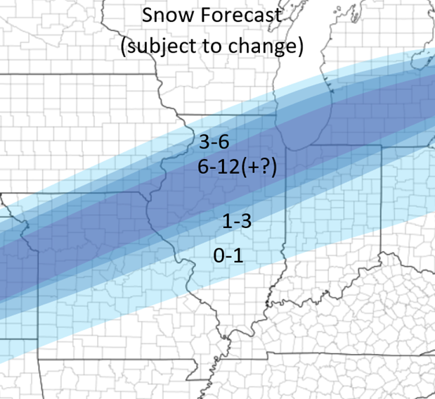 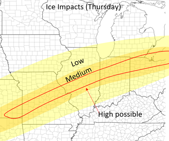 SEVERE WEATHER: Severe weather is possible during Wednesday Night in the Southern Plains and on Thursday over the lower Ohio and Mississippi River Valleys. Wednesday Night the storms will fire around and after Midnight over areas near the Red River Valley in Oklahoma and Texas. These storms will continue northeastward during the nighttime hours. Thursday is potentially more significant although some details still remain unclear. The system starts to veer out so winds because slightly more southwesterly in the lower levels, but the major concern is the lack of instability in place. Despite ample dew points, the lack of instability limits storm growth and how strong storms can get on Thursday. Nonetheless, some strong to severe storms will be likely in these regions. See the outlook maps I created below (also poste in the outlooks tab). Stay tuned and more updates to come soon! 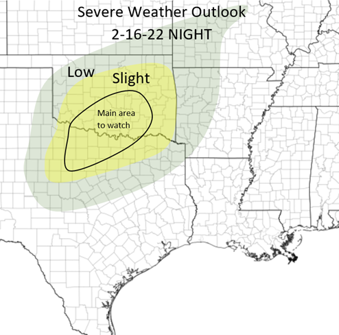 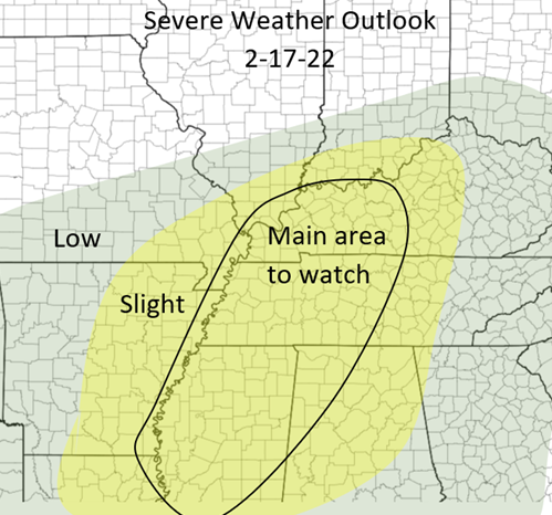
0 Comments
Good afternoon everyone! This is the second main update for the winter storm that will be going through our region over the next 48-54 hours! There have been some minor changes since but generally not much has changed since the last post. Currently, it is raining over a majority of Illinois. Throughout the night tonight and tomorrow, this will change over to wintry mix, then to snow from northwest to southeast. Some of this is expected to freeze over so most areas will likely have a layer of ice tonight when it changes over to snow, so be careful! See the "transition to snow" map below: 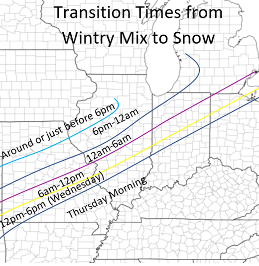 Depending on where you live, there will still be two main times of heavier precipitation during this event. Tuesday night-Wednesday evening and Thursday morning into the afternoon. The first patch is most significant and will bring the highest amounts of snow with it. Below are the snowfall totals for each time period. Daytime is 6am-6pm and nighttime is 6pm-6am 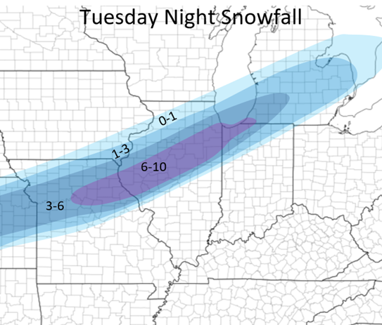 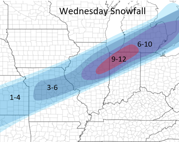 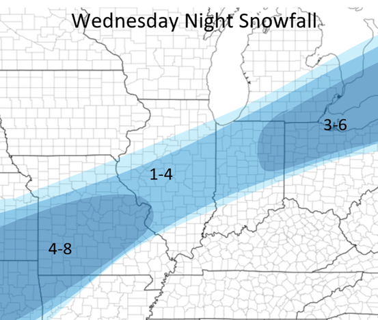 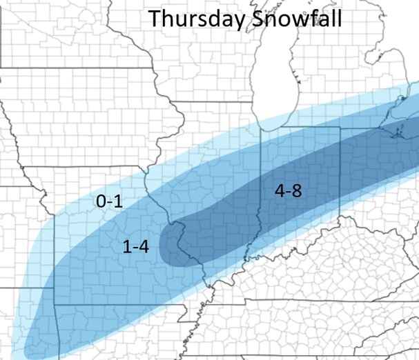 Below is currently my forecast with this event from now until Thursday Night. NOTICE that the Chicago region is more on this forecast than from the maps above. This is due to likely lake-effect enhancement Wednesday night and Thursday which the models are currently showing. Generally not including this, the Chicago area will receive 5-10 inches of snow but due to some more snow later on, the amounts are higher. This forecast can still change some although at the current time this is my best thinking due to the recent model trends. It is important to note that some areas within the "12-18" possibly could receive 18-20 in very localized areas and some could receive 22-25 in the 16-22 area. This is due to very small areas of heavy bands of snow but generally in these areas the general totals will be what is forecasted below: 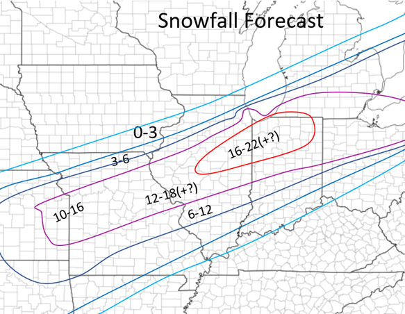 For more local forecasts for Central Illinois: Jacksonville: 14-18 inches Springfield: 14-18 inches Decatur: 14-18 inches Bloomington: 15-20 inches Champaign: 15-20 inches Peoria: 12-16 inches Quincy: 10-14 inches Below I also have a map with the ice risk. Above the purple line ins during the first half of the event and below the line is the latter half of the event. This is all for now, if there are any major changes I will provide updates! 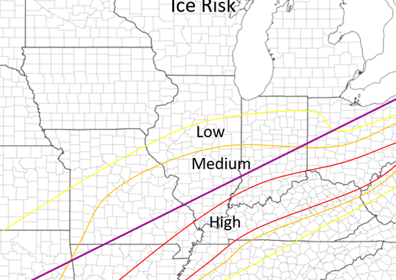 Good morning everyone! This is the first update regarding the winter storm coming into the Central US later this week! Scroll down to the section below the next few paragraphs, these below are just setting up the standards for 2022 weather postings: First, since this is my first main weather post of 2022 and the first time I have used my site in awhile, I wanted to give some expectations for weather related forecasts and posts from my end this year. I will be focusing on weather even more this year and will plan on continuing on forecasting and even learn more along the way this year. Thankfully through the years I have built somewhat of a reputation through friends and local people for my weather forecasts and I ho0pe to continue that this year and into the future. By doing this, I will post more forecasts on here this year as opposed to facebook to save forecasts and to have the updates and posts more accessible throughout a wider audience than just through facebook. Generally, my forecasts and updates will be posted in the following times: Major Winter Weather: 1st update: 48 hours prior, then update forecasts very 12ish hours following the initial post. Minor Winter Weather: 36 hours prior, 12 hours prior, and right before the event Severe Weather Outlooks: Beyond 3 days: if it is apparent of a major severe weather set up Afternoon of 3 days out Afternoon of 2 days out Morning of day before Evening of day before Morning of the event Severe Weather postings will come at a variety of times within 2 days of the event depending the significance of the event. The outlooks will generally only be posted and discussed within a day or two of an event unless a major set up looks likely, and posting updates farther out in advance will typically get more certain as the event gets closer. WINTER STORM: Now since I have set up the expectations of posting for these set ups this year, I will now dive into the first major winter storm of the season and perhaps the most impactful winter storm into our region in recent years! There is still major model disagreement over multiple parts of this set up so most of the following forecasts and discussion is subject to change, but mostly just to put a baseline on what to expect in the coming days. Generally, these large set ups (as most setups) become much clearer within a day of this event occurring. The trickiness of this system is how much precipitation this is bringing to the area ( much higher totals) and the longevity of the event which will last for at least 48 hours from Tuesday night to Thursday evening! Timing: Tuesday night to Thursday evening Worst times (Illinois): Wednesday morning 12am-12pm, Wednesday night 9pm-12pm Thursday Impacts: All including double digit snowfall totals, large sleet and ice accumulations, and strong wind Wednesday Night and Thursday For this post I will generally just show my current forecasts and snowfall model runs and dig more deeply into the discussion of the system when models align more with one another. Generally there is a more southern track of the system which the long-term models are sticking too and there's a more northern track which the NAM is sticking to at the current time (see snowfall amounts below). There will be two main waves of precipitation, one Wednesday morning and one Thursday morning (see timings above), although precipitation will fall throughout this entire event from start to stop. This will actually start out as rain Tuesday evening across most of central Illinois and change over to snow overnight. The exact placement of the changeover from snow/sleet/ice/rain is all dependent on the track of the system and at the current time it is not too clear, but a general idea where all of this is pictures below on the maps: This is all for now! Updates with more details to come a few times in the next 48 hours so stay tuned! Again, these are all general thoughts at the current time that are subject to change but based off the model trends this far out these are good ideas to what the system might produce! 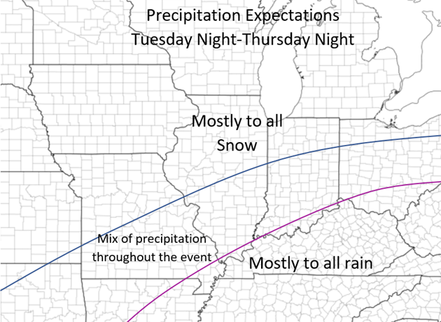 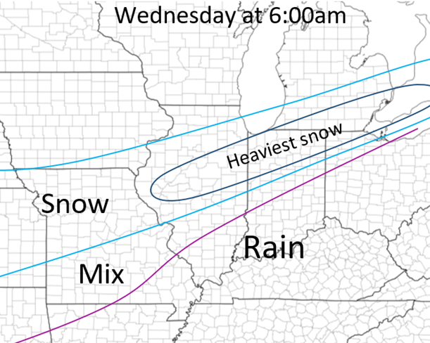 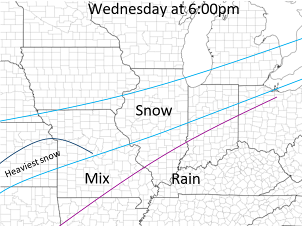 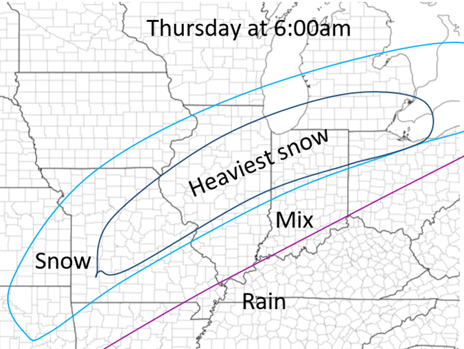 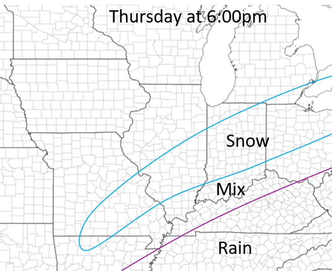 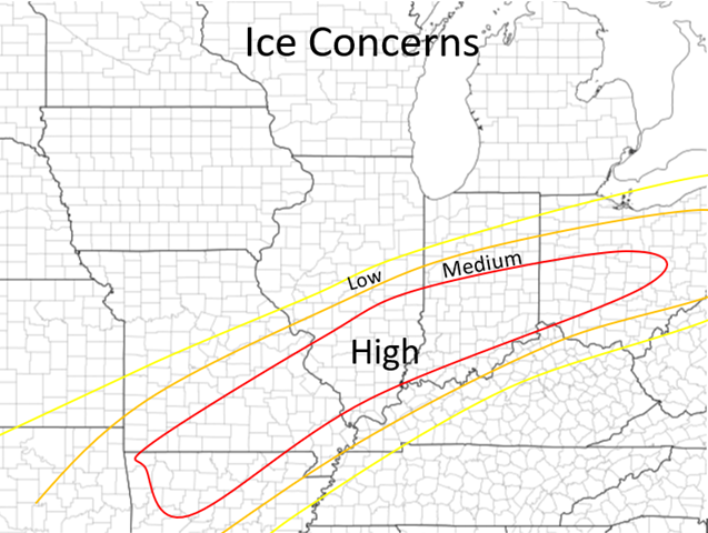 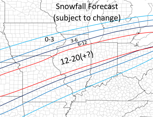 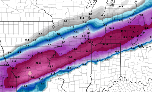 NAM snowfall (only until 12pm on Thursday) 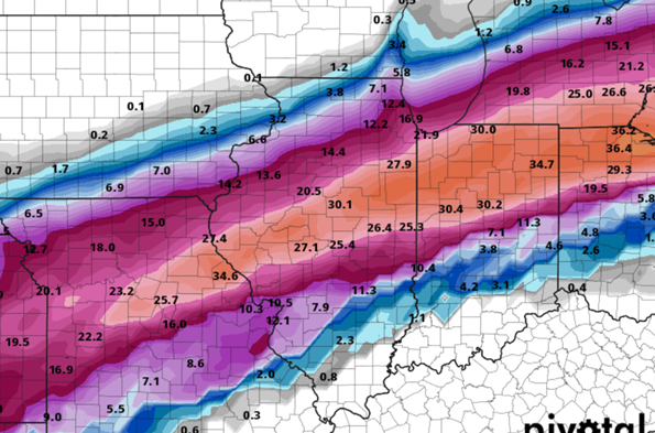 GFS snowfall 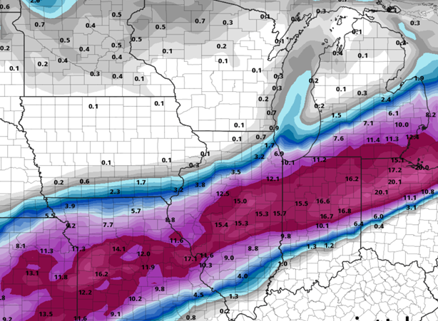 GDPS snowfall
Good afternoon! This is about the heightened severe risk coming into the Mid-Mississippi River Valley today and the nest 3 days as well (briefly). Storms will fire in Northern/north-central Missouri and nearby areas mid/late afternoon. These storms will eventually form a line overnight and move central MO and the western half of IL. Supercells will develop from extreme northwest MO and form a line of cells into northeaster/east-central Missouri. All hazards will be likely including a couple tornados with these early storms. Eventually all of these storms will form a line after dark, then form bow echo(s) and move southeast/eastward into parts of IL and other parts of Missouri. Flash flooding risk is also high because the storms will train along the same areas in Missouri for hours and several inches of rain are possible this evening and overnight. The next three days also have at least a low risk of severe weather in our area, although specifics are still a little unclear. Friday and Saturday having much higher risk than Sunday's threat, but nothing too alarming yet. Stay tuned and here are some maps below! 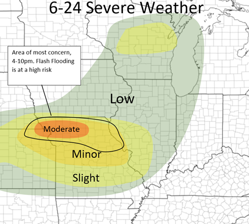 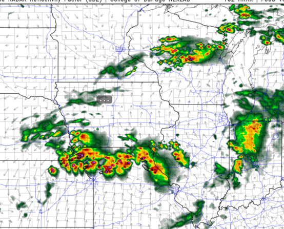 HRRR at 7pm 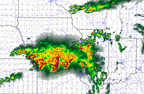 HRRR 12am tonight
Good morning! In this post, I will briefly lay out tomorrow's severe threat. I will have a much more detailed post tomorrow morning. The models are all hinting at a more heightened severe weather risk tomorrow across the Midwest the models do not agree on a few specifics. Generally, there will be a MCV (Mesoscale Convective Vortex, basically just a weak low pressure that forms within a large cluster of storms) coming out of Iowa sometime during late-morning from storms in the central Plains overnight. The placement of these and the values of certain ingredients are a bit unclear, but it is safe to say that this will cause some severe weather, if not some significant severe weather in the Northern half/third of IL early afternoon tomorrow. The NAM has it shooting across the I90 corridor whereas the HRRR has it shooting across just north of the Highway US 24 corridor and north. All threats will be possible with this cluster of storms. This will continue to move east and form more of a damaging wind threat the more east it travels into IN/MI and into OH by late afternoon. A second area will develop in the afternoon along the Mississippi River and west. For now, these will pose a large hail threat primarily, then more of a damaging wind threat over NE and central IL after dark, but some specifics are unclear with the movement of the MCV before this which could inhabit and cap the environment behind it for a longer period of time if it moves at a slower pace. We will see! Below I have a outlook map, a possibilities map. Stay tuned! 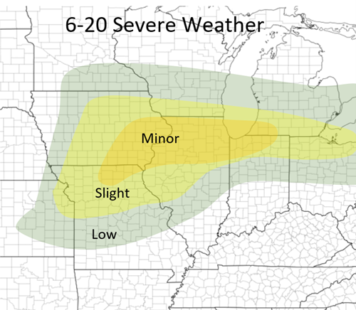 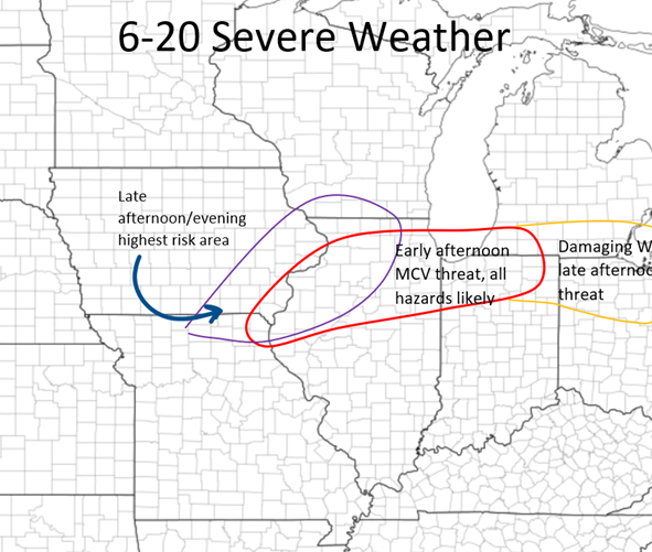 Good morning guys, who's ready for another full day (two days coming actually) of severe weather! I am! TODAY: There will be a small area of heightened risk over central and south-central IL this afternoon. Hail and Damaging Wind threat (especially hail is the main concern) from along I72 and south. There is an isolated tornado threat with some small wind shear, but not a strong threat. These storms will form along and near I72 from Springfield to Pittsfield between 1-2:30, organize, and continue southeast. The environment is very favorable for strong updrafts with CAPE values in the 2,500-3,500+ range within a range of Springfield and west. I would assume they form along a small boundary that was set out from this morning's storms. So here is my outlook for today as well as a timing map for this small line of storms! Stay tuned!  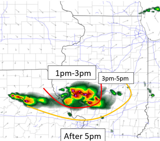 Good afternoon guys! It has been awhile since a good severe weather day in Illinois! Well, the next three days are all going to be worth watching, especially today (Friday) and Sunday! I will mostly discuss today's threat and briefly touch on tomorrow's and Sunday's. I will go more details on those on the day of! So, even just 6-12 hours before this severe weather setup on folds, the HRRR and the NAM are disagreeing with each other like they always do and this is making things complicated. Both agree that there will be severe storms, and for IL both do agree that there will be some severe storms that will fire after dark in central IL. But, the main action this afternoon across Indiana and Ohio is what is being questioned. The NAM has boldly stuck with this line forming around 3/4 in NE Indiana and NW Ohio and charging south to southeast, this being mostly a damaging wind threat but Hail and a couple Tornadoes are possible as well. The HRRR is is showing little development until very late, near sunset further south with not as significant as a threat. Although the HRRR was more correct with yesterday's storms, I will guess the NAM to be more in the right today as with what I am seeing with the ingredients as well as there are already a couple storms forming just north of me here in East-central IL which means that the atmosphere is already primed up. TIMING: Eastern Indiana (into central) and much of the western half of Ohio, be on guard from 3-7 this afternoon as that line segment heads south. If the HRRR will be correct, then there will be little development until 6/7pm tonight. FOR ILLINOIS: most storms will not initiate until near or after dark due to the front stalling across southern Iowa and Northern IL, with very high instability (3,000-4,000+) among other factors, but develop late due to an enhancement of South to Southwest winds in Iowa which will interact more with the front and cause storms to fire after dark (9/10ish for the first storms). Due to high instability and high lapse rates, HAIL will be the greatest outmost concern with these (along with damaging wind), which could produce large to very large hail within a small corridor from Southern Iowa and Central IL. These storms will mostly start off in Iowa but expect by midnight a line of storms from Southern Iowa to West-central Indiana, most storms within this line being strong to severe. This threat will terminate by 3/4am hopefully. A tornado or two is also not completely ruled out but wind shear will not be as strong as it is across the IN/OH region this afternoon. So today should be watched and also look at the radar before you plan and going anywhere in each region and the specified times above. 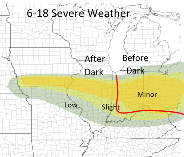 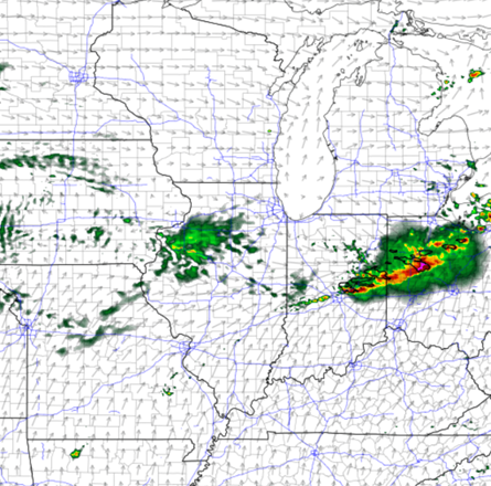 NAM at 5pm 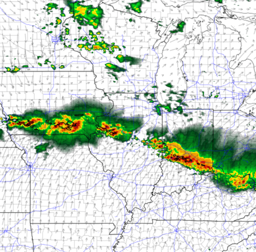 NAM at 12am Below I have my thoughts on the outlooks from Saturday and Sunday. I will have many more details in the next two days! These are subject to change. Stay tuned! 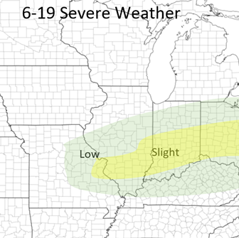 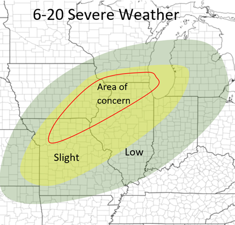 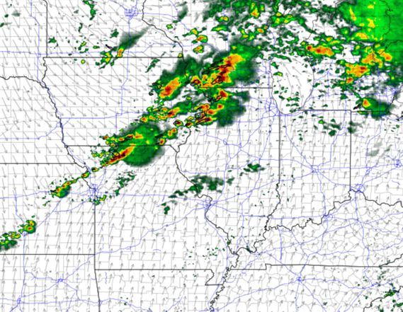 NAM 7pm Sunday
Good morning! FINALLY! An active day of severe weather in Central Illinois! It has been way too long! I am excited to get out and watch and study the storms today! TIMING: 2-6pm (west of IL River) 5:30-9:3pm (east of IL River) HAZARDS: ALL severe weather components today (even a couple/few tornadoes are possible) I am going a little bold within our region today. Below in my outlook, I have put a more specialized risk area for the small region in Central IL that will be at highest risk. I was going back and forth between just keeping it with Slight or bumping it up but based off the latest 12z NAM and HRRR models, I have a MINOR risk area for some part of Central IL today! The Storms will be developing along and south of a MCV (Mesoscale Convective Vortex) from the storms overnight from the Great Plains, which will be coming out of IA/MO mid-afternoon. with CAPE values in the 1000-1500+ range, dewpoints in the lower to mid 60s, a strengthening low level jet (late), and a small area of strong upper level winds (from 4pm and on, this virtually develops out of nowhere), this is a PRIME environment for some severe weather today. This event is actually very similar to the July 15 2020 event in that we have a MCV coming out of the same area and will have a line of storms develop along and just south of it with nearly the same conditions. On that day there were a few tornadoes in our region including one wide one I photographed! So these storms will ignite along and the the Mississippi River in the 3-5pm timeframe, and will race east in Central IL. I WOULD NOT be surprised if a couple renegade cells form in front of this line (2-5pm) and could pose a hail/tornado threat as well, as the HRRR is hinting on this possibly occurring. This will finally cool off in Eastern IL and Western IN by 8-10pm tonight The other area is down in the Ozarks and the Ohio River/Mississippi River region. These storms will form after dark in the Ozarks to Eastern Oklahoma and will race Northeast/East. Some may form in the Ohio/MS River region early overnight as well. All threats with this will be possible but damaging winds are the main component with these! That is all for now! Stay tuned for tomorrow's Severe weather as well, if anything changes today I will update! 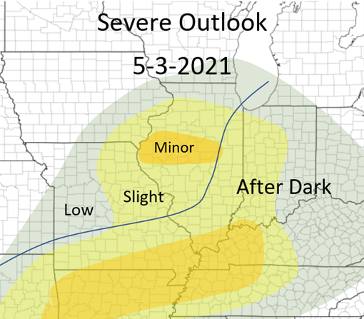 Today's Outlook  NAM at 7pm 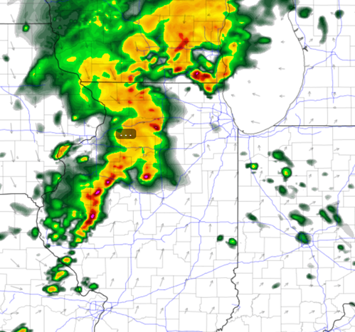 HRRR at 6pm 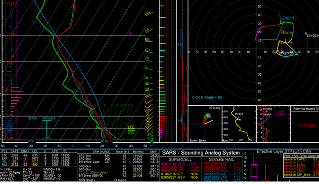 NAM weather sounding at 6pm showing ample CAPE (the area between the blue dotted line and the red line), Dew Point, and Wind Shear!
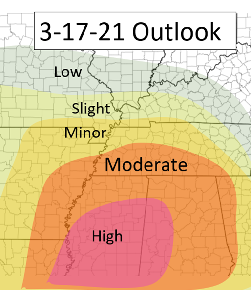 Good morning everyone! Today's severe weather risk is heightened and all should be on guard in these areas. Many tornadoes will be possible and violent long tracked tornadoes are possible as well. Stay alert! Although there are still some slight differences between the models, the models both agree on a big severe event taking place. Here are the specifics: There is a large area that will be under a Moderate to High risk for severe storms today, as well as A FEW rounds of storms, not just one! AR/MO/TN/KT: This region will see a few rounds storms during the day. the first round will be lifting along the warm from reaching the Memphis area by around the 8am timeframe. These will mostly be sub severe although a couple could be severe. This batch will slowly continue northeastward along the warm front. This is where the models start to diverge, but not by much. The HRRR shows a new line of convection coming into the eastern Arkansas region by late 10am. By this time, CAPE values just south of this will be 1,000-1,500, and with enough wind shear, this line could turn severe as it pushes east and continues to strengthen. The HRRR continues to push this to the east into Western Tennessee by noon and really strengthens this line, and continues to stay on the edge of the warm front, tapping into more favorable environments just to the south. This line will dissipate likely by the mid afternoon in central TN but this is the first main round of concern for this region. Below I have a picture of the 1AM HRRR at 11am showing this region. 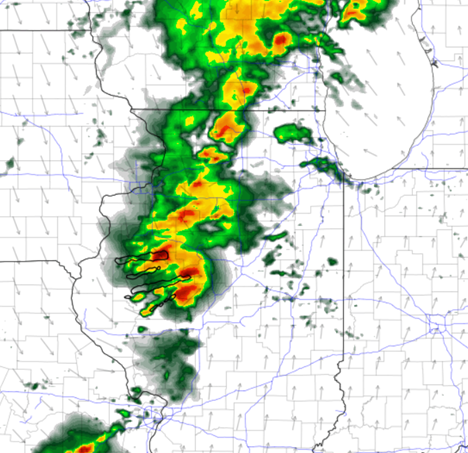 There will be enough clearing behind this system for storms to fire along the advancing Cold front, and possibly again along the warm front in place from extreme southern MO and through northern and central Tennessee. The line of storms triggered by the cold front will reach Eastern Arkansas by 4-6pm likely. Depending how much destabilization will occur since the passing of the early afternoon storms, will determine how strong these storms can get. Nonetheless, these will be strong but the severe threat including multiple tornadoes will be dependent on this. This line will continue to push East Northeast across the MS River and will continue into Tennessee in the early overnight hours. LA/MS/AL Although the threat is quite high in the other region, this area is the greatest concern for the worst threats from this event. In the early afternoon, cells will likely develop in the warm sector in eastern MS and AL (in the pink circled area in the map below. This will be round 1 and these could bring hail as well as tornadoes. These will start to develop around 1pm. The next main threat is the line that I had already mentioned for the area above. There is a bit more of a heightened risk with this line more south starting in NE LA and into central MS. The line will cross over the MS river at around Duck and will continue into MS and then into AL during the late evening and overnight hours. This line will have every severe threat including the threat of a few tornadoes and some that could be dangerous and long-tracked (triggering the High Risk). Be very careful during the early overnight hours in this region. THE MAP BELOW shows (in pink) where the threat of the afternoon supercells and then (in the purple) where the highest nighttime threat is with that advancing line of storms. All for now, stay safe everyone! 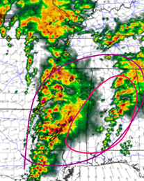 Good morning guys! This is the main official post regard the snow for today and tonight here in IL. Nothing has really changed since my last post. Generally, 1-3 inches of snow fell in most of IL last night. The main round of snow is still to come! The snow is starting to push north into Southern IL as of 9am this morning. This will continue to push north to northeast as the day progresses. Below I will have a storm timing of snow map below: 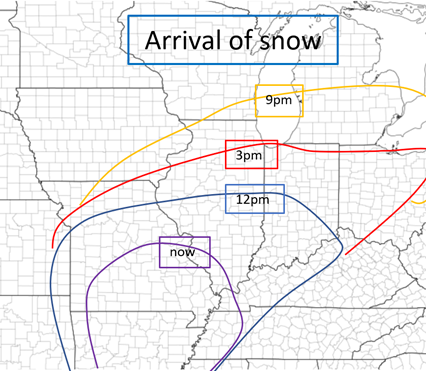 Next, I will have a timing of when the heaviest snow will fall during this event. This map is below: 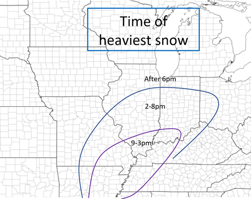 NOW, time for the snowfall forecast. Generally not much has changed since last night's forecast. I am going a little bullish, especially with the 10-14, but latest models suggest that this is possible/likely. We shall see! 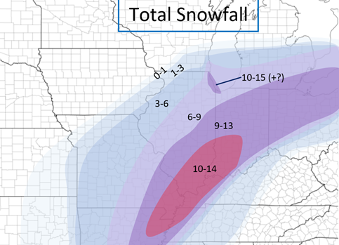 All for now! Stay tuned for Wednesday/Thursday's system. The latest NAM suggests 4-8 inches for central IL Wednesday-Thursday. Stay tuned!
|
AuthorWrite something about yourself. No need to be fancy, just an overview. Archives
January 2024
Categories |
 RSS Feed