|
Good morning! In this post, I will briefly lay out tomorrow's severe threat. I will have a much more detailed post tomorrow morning. The models are all hinting at a more heightened severe weather risk tomorrow across the Midwest the models do not agree on a few specifics. Generally, there will be a MCV (Mesoscale Convective Vortex, basically just a weak low pressure that forms within a large cluster of storms) coming out of Iowa sometime during late-morning from storms in the central Plains overnight. The placement of these and the values of certain ingredients are a bit unclear, but it is safe to say that this will cause some severe weather, if not some significant severe weather in the Northern half/third of IL early afternoon tomorrow. The NAM has it shooting across the I90 corridor whereas the HRRR has it shooting across just north of the Highway US 24 corridor and north. All threats will be possible with this cluster of storms. This will continue to move east and form more of a damaging wind threat the more east it travels into IN/MI and into OH by late afternoon. A second area will develop in the afternoon along the Mississippi River and west. For now, these will pose a large hail threat primarily, then more of a damaging wind threat over NE and central IL after dark, but some specifics are unclear with the movement of the MCV before this which could inhabit and cap the environment behind it for a longer period of time if it moves at a slower pace. We will see! Below I have a outlook map, a possibilities map. Stay tuned! 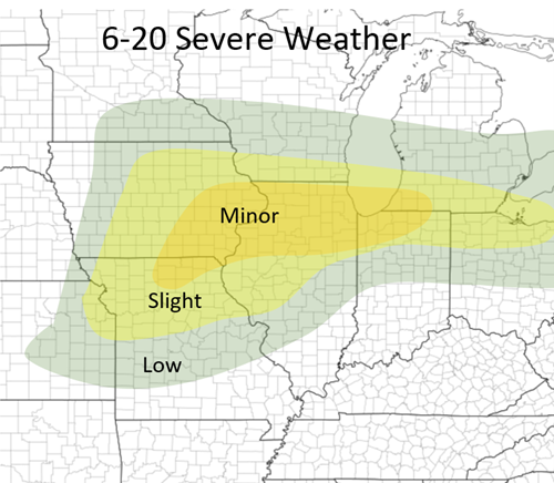 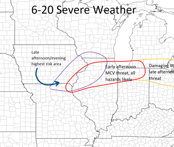
0 Comments
Leave a Reply. |
AuthorWrite something about yourself. No need to be fancy, just an overview. Archives
January 2024
Categories |
 RSS Feed