|
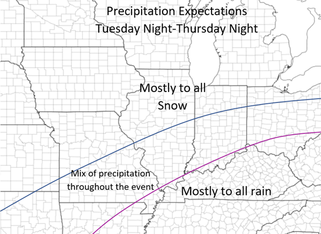
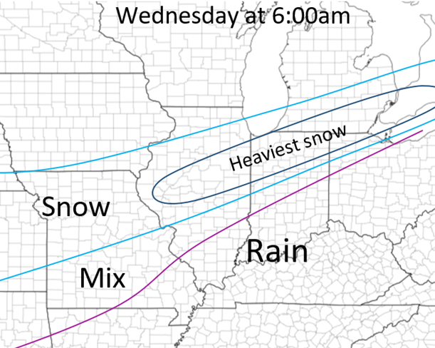
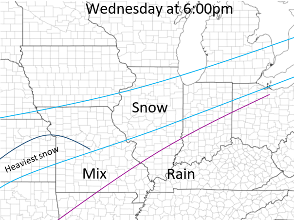
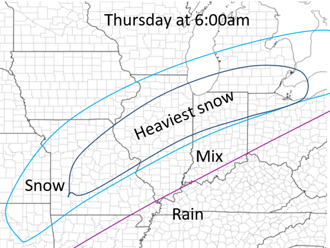
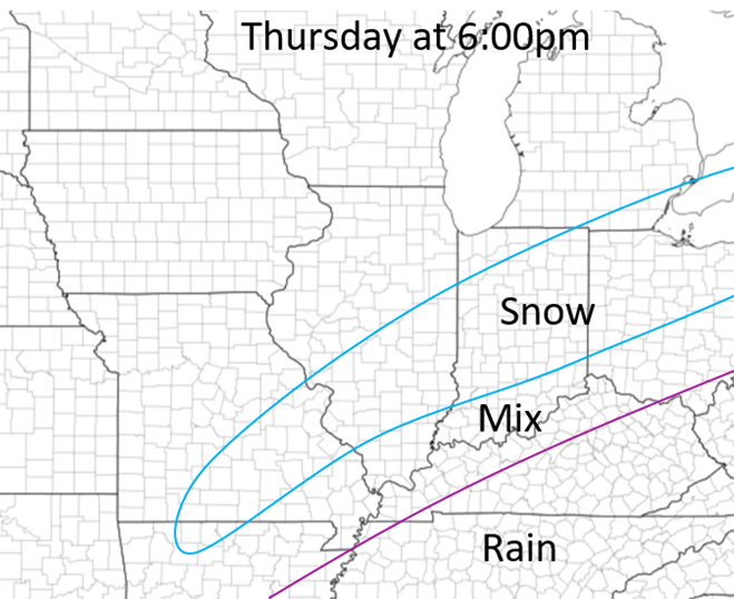
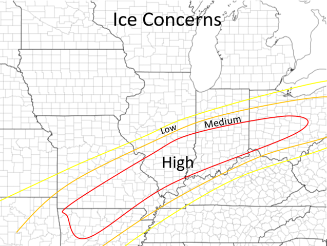
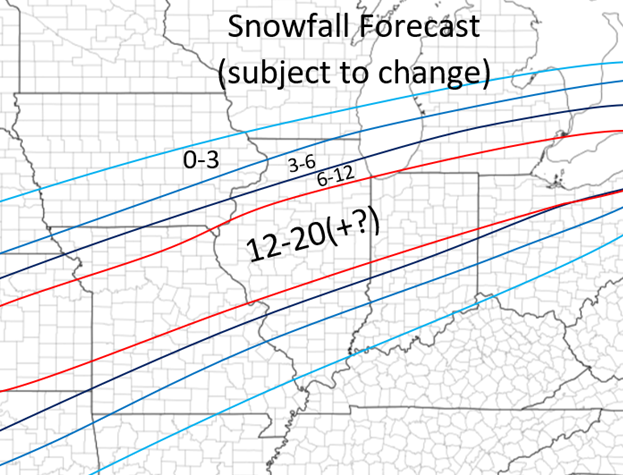
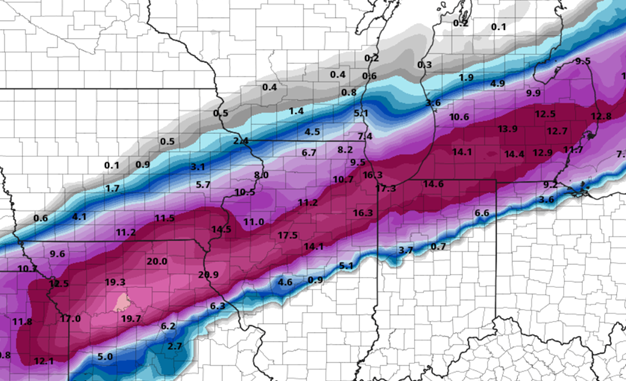
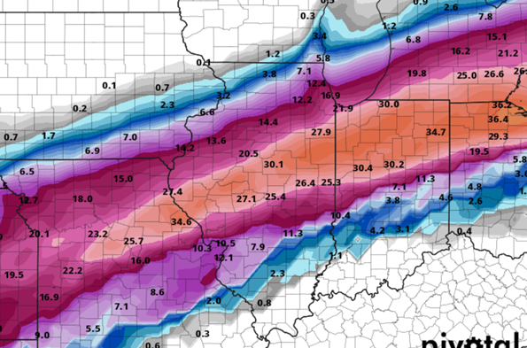
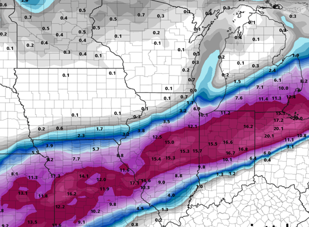
Good morning everyone! This is the first update regarding the winter storm coming into the Central US later this week! Scroll down to the section below the next few paragraphs, these below are just setting up the standards for 2022 weather postings: First, since this is my first main weather post of 2022 and the first time I have used my site in awhile, I wanted to give some expectations for weather related forecasts and posts from my end this year. I will be focusing on weather even more this year and will plan on continuing on forecasting and even learn more along the way this year. Thankfully through the years I have built somewhat of a reputation through friends and local people for my weather forecasts and I ho0pe to continue that this year and into the future. By doing this, I will post more forecasts on here this year as opposed to facebook to save forecasts and to have the updates and posts more accessible throughout a wider audience than just through facebook. Generally, my forecasts and updates will be posted in the following times: Major Winter Weather: 1st update: 48 hours prior, then update forecasts very 12ish hours following the initial post. Minor Winter Weather: 36 hours prior, 12 hours prior, and right before the event Severe Weather Outlooks: Beyond 3 days: if it is apparent of a major severe weather set up Afternoon of 3 days out Afternoon of 2 days out Morning of day before Evening of day before Morning of the event Severe Weather postings will come at a variety of times within 2 days of the event depending the significance of the event. The outlooks will generally only be posted and discussed within a day or two of an event unless a major set up looks likely, and posting updates farther out in advance will typically get more certain as the event gets closer. WINTER STORM: Now since I have set up the expectations of posting for these set ups this year, I will now dive into the first major winter storm of the season and perhaps the most impactful winter storm into our region in recent years! There is still major model disagreement over multiple parts of this set up so most of the following forecasts and discussion is subject to change, but mostly just to put a baseline on what to expect in the coming days. Generally, these large set ups (as most setups) become much clearer within a day of this event occurring. The trickiness of this system is how much precipitation this is bringing to the area ( much higher totals) and the longevity of the event which will last for at least 48 hours from Tuesday night to Thursday evening! Timing: Tuesday night to Thursday evening Worst times (Illinois): Wednesday morning 12am-12pm, Wednesday night 9pm-12pm Thursday Impacts: All including double digit snowfall totals, large sleet and ice accumulations, and strong wind Wednesday Night and Thursday For this post I will generally just show my current forecasts and snowfall model runs and dig more deeply into the discussion of the system when models align more with one another. Generally there is a more southern track of the system which the long-term models are sticking too and there's a more northern track which the NAM is sticking to at the current time (see snowfall amounts below). There will be two main waves of precipitation, one Wednesday morning and one Thursday morning (see timings above), although precipitation will fall throughout this entire event from start to stop. This will actually start out as rain Tuesday evening across most of central Illinois and change over to snow overnight. The exact placement of the changeover from snow/sleet/ice/rain is all dependent on the track of the system and at the current time it is not too clear, but a general idea where all of this is pictures below on the maps: This is all for now! Updates with more details to come a few times in the next 48 hours so stay tuned! Again, these are all general thoughts at the current time that are subject to change but based off the model trends this far out these are good ideas to what the system might produce! NAM snowfall (only until 12pm on Thursday) GFS snowfall GDPS snowfall
0 Comments
Leave a Reply. |
Details
AuthorWrite something about yourself. No need to be fancy, just an overview. Archives
January 2024
Categories |
 RSS Feed