|
Good evening! This will be my first post on my sight. I decided back in November to make a weather blog section of my site where I can share my briefings and forecasts instead of cluttering my Facebook with them and I can actually find them when I want to go back and revisit the briefings, plus it's somewhat easier to do this way! We have an interesting system coming into the Midwest here on New Year's Day, 2021. There's a potential of a possible Ice Storm here in some areas. There are still some uncertainties which will become clearer during the day Thursday, in which I will make another post Thursday evening when the models have more of an agreement. Generally, the system arrives Thursday night into Arkansas and moves northeast into the lower Wabash River region Friday afternoon. Freezing Rain will start out about anywhere in IL, depending on where you are. The Freezing Rain will start along the I72 corridor around 4-6am Friday morning. All models have it changing to rain at some point but whether it rains most of the time (Track 1) or very little of the time (which means much more freezing rain, Track 2) is still uncertain. Track 1, which the NAM seems to have stayed with, depicts a system that tracks more north, in which case shifts the area of freezing rain concern more to the north. Here's a map I created below showing this. 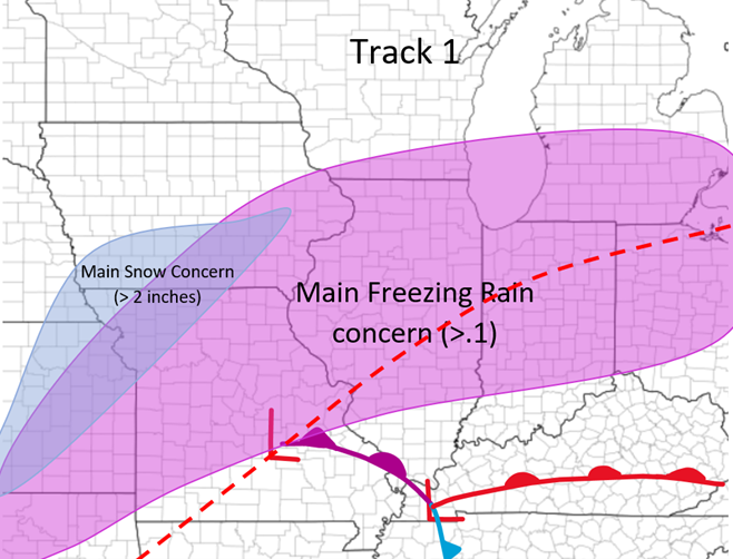 Track 2, which the HRRR and RAP are sticking with, tracks the system more south, in which case shifts the area of Freezing Rain more to the south. Here's a map below I made. 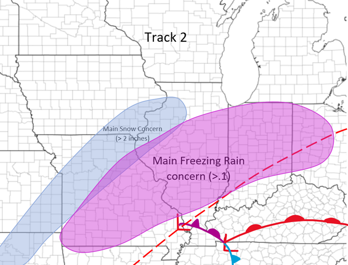 This is where things stand right now with this system. I will have another update Thursday Night, and hopefully there will be more agreement by then. There is also a possibility of some light snow in central IL Saturday night that is still unclear as well!
Thanks for reading! Colin Dobson
0 Comments
Leave a Reply. |
AuthorWrite something about yourself. No need to be fancy, just an overview. Archives
January 2024
Categories |
 RSS Feed