|
Good afternoon! This is my last post over today's storm. This morning I posted a couple maps on my Facebook as I did not have time to create a post due to the first day of classes today! This is a more detailed update than that one this morning since I have had some time free up this afternoon! This morning here in Champaign we received less than an inch of snow with a brief window of precipitation this morning. other areas received some ice to the south and west but the precipitation this morning did not go north of I72 in Illinois for the most part as expected. This is the only snowfall that the I72 corridor will see during the whole event besides possibly a dusting at the tail end of the event midday Tuesday. It is currently 2:30 in the afternoon and the first snow bands are starting to come across the Mississippi River into West-central IL (more specifically the Rock Island/Mercer/Henderson/Warren/Knox county areas). Expect this to continue moving eastward and "fill in" the entire north third of IL by 7pm or so this evening. This will continue as light to moderate snow overnight and into the morning on Tuesday. The Snow will generally tapper off from West to East and IL should generally be in the clear by Tuesday afternoon. The snowfall forecasts have generally stayed the same today for the most part, besides maybe move a tad to the north. There is a possibility that the Chicago metro area may see 6-8 due to a small enhancement affect from the lake, but we will see. The HRRR picks up on that and the NAM does not. Below is my Snowfall forecast: 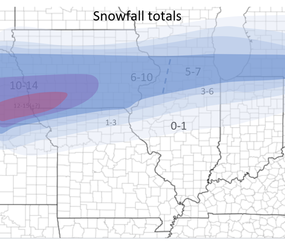 As I discussed in my first post. There will be an ice component to this system as well. Generally in IL this area will encompass everything between I72 and Highway 24. This small region should receive around a tenth to two tenths of Ice during this system but a few localized areas of upwards of a three tenths of an inch of Ice is possible. Here is that area of concern below. Some areas to the north May receive some Ice (mostly Sleet) as well but the main concern will be that area between the I72 and Highway 24 corridors. 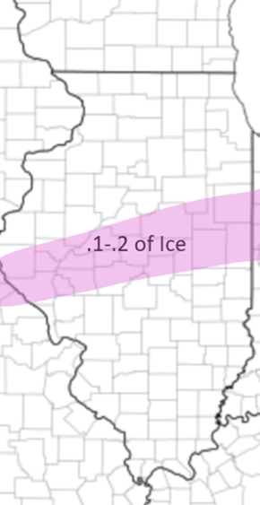 Below I will attach a few of the models snowfall maps and precipitation maps at Midnight Monday Night. Also watching a small disturbance Wednesday that could bring 0-2 inches to the Central and Southern IL regions. Stay tuned! Thanks for reading! 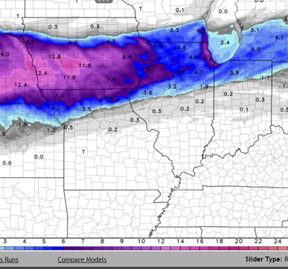 HRRR Snowfall 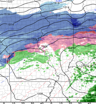 HRRR Midnight Monday Night 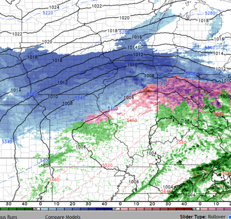 NAM Midnight Monday Night
0 Comments
Leave a Reply. |
AuthorWrite something about yourself. No need to be fancy, just an overview. Archives
January 2024
Categories |
 RSS Feed