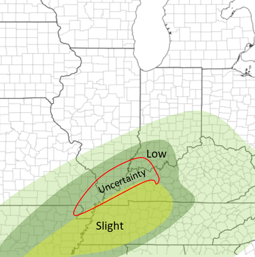
 There appears to be a growing confidence that there will possibly be severe weather in the Mid-Mississippi River Valley tomorrow ahead of an advancing cold front, especially tomorrow afternoon. Although there are still some uncertainties. Currently the HRRR and RAP show a bit more backed system than the NAM does. The HRRR shows an "opening" of rain for Southern IL during the day Sunday, and also has the front a tad slower. Therefore having some cells developing early tomorrow afternoon across Southern IL and the rest of the region in the "Uncertainty" area. The Nam has a line beginning to form late morning from a boundary that was set during the very early morning storms in extreme Southern IL by late morning and ending by noon for that region. So, two completely different scenarios for Southern IL. Although for areas to the south of that in the "Slight" area, both models agree that a line of storms will develop and move through Sunday afternoon and into the evening hours more east. Due to more of a linear structure, this will largely be a damaging wind threat, although it appears that there will be a chance for couple tornadoes based on recent model trends showing some lower-level wind shear (S/SSW winds lower and SW/WSW winds in the mid-levels), as well as low chances of hail, although if the CAPE values (instability) continue to rise, that may be more possible (currently 800-1,200). Definitely something I will continue to watch and update! Stay tuned!  HRRR at 3pm Sunday 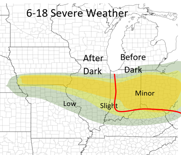 NAM at 2pm Sunday 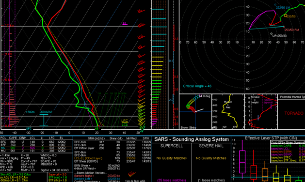 NAM Forecast Weather sounding for Western Kentucky at 2pm Sunday.
Temperatures and Dew Points are in the mid 60s ML Cape (area between the temperature (red line) and the air parcel (dotted line)) is 900+ (bottom left hand side) with a LI (Lifted index) value at -3 (anything less than 0 is unstable) Wind shear (hodograph in the top left): showing winds at the surface 10-15mph from the S/SSW, and winds in the mid-levels 25+ out of the SW. Interesting with the little area of less wind at about 800mb All of this shows severe weather is definitely possible along the cold front tomorrow afternoon!
0 Comments
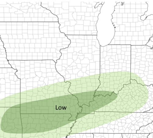 This event is mostly an overnight event. Severe weather is possible in southern IL 9pm-3am, although the chances are low. Still expect some thunderstorms during the night. Main threat would be damaging wind and hail, as well some possible flash flooding. A tornado is unlikely. If anything changes I will have an update!
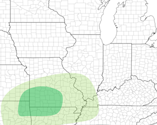 Saturday 1-30's outlook. Low Risk of Severe weather in the Ozarks region between 2-6pm Saturday afternoon. More updates and discussion tomorrow when it becomes more clear
Hello everyone!
I am not going to share this post on my social platforms but figured some people may wonder onto this page and see "What else is Colin doing." This page is a break from my typical Weather briefings and reports. In 2021 I am going to challenge myself to new weather forecasts and thoughts just to get better at doing these kinds of things, learn more myself, and become more experienced so I can get the trust of others. Weather and storm-chasing are just a hobby of mine and not a career and not what I am going to school for but through my desire to learn more about another hobby of mine I am ready to continue putting my experience out there. So besides my usual weather briefings and or reports, I am going to start doing severe outlooks based on what I think is going to happen and where. Basically similar to the SPC's outlooks but I want to challenge myself to do it all on my own, compare mine with there's, and see how right or wrong I am about a severe weather event. This will not take this year for me to fully develop and I am sure I will continue to change techniques I use etc. I usually make my own outlooks mostly for my briefings and obviously will still use them in them. This page is generally just for the outlooks themselves so myself and or someone doesn't have to read the whole briefing to find an outlook. I am also going to do outlooks for most of the spring and summer for anywhere in the central and southern US. More or less just to get me more experience with doing this and get me better practice before our own season in the Spring and Summer. All this is fun to me, it gives me something else to do and focus on, as well as exploring more interest in this field. I can't wait for the 2021 season and look forward to many fun systems to look at and forecast! |
AuthorWrite something about yourself. No need to be fancy, just an overview. Archives
June 2022
Categories |
 RSS Feed